Skip to search
Skip to main content
Digital Commonwealth
Sign Up / Log In
Search for
Search
Search
Search
Basic
Advanced
Explore
Map
Collections
Institutions
Formats
For Educators
Primary Source Sets
Lesson Plans
Using Primary Sources
Searching Digital Commonwealth
For Institutions
Join Digital Commonwealth
Conferences, Trainings, & Events
How to Contribute Collections
Digitization Services
Board & Committees
Frequently Asked Questions
About
About Digital Commonwealth
News & Announcements
Copyright & Terms of Use
Harmful Content Statement
Partners
API
Contact Us
Boston Public Library
Norman B. Leventhal Map Center Collection
/
Boston and New England Maps (Collection of Distinction)
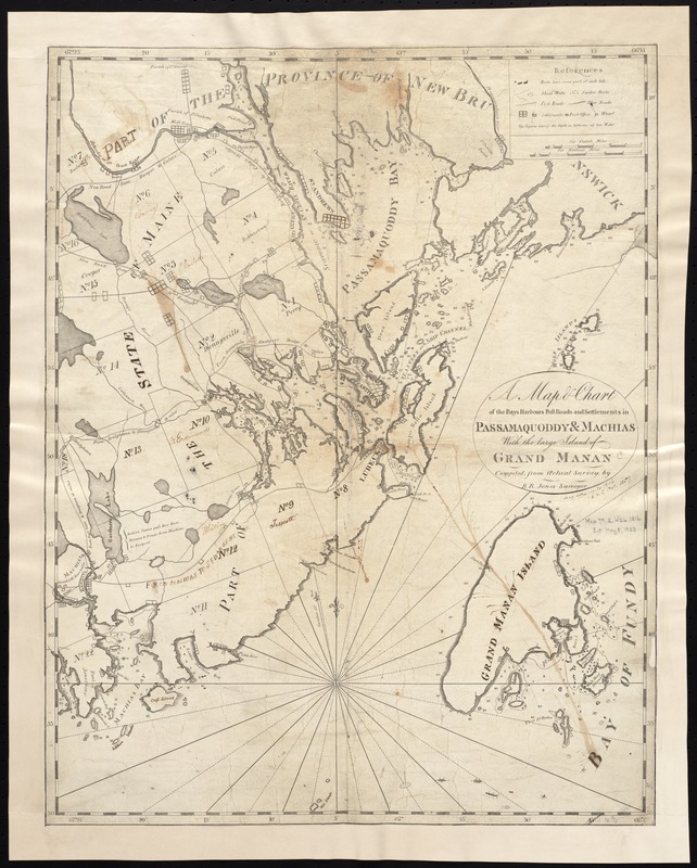
A map & chart of the bays harbours post roads and settlements in Passamaquoddy & Machias with the large island of Grand Manan
A map & chart of the bays harbours post roads and settlements in Passamaquoddy & Machias with the large island of Grand Manan
×
Item Information
Title:
A map & chart of the bays harbours post roads and settlements in Passamaquoddy & Machias with the large island of Grand Manan
Creator:
Jones, B. R. (Benjamin Richards), fl. 1804-1810
Name on Item:
compiled from actual survey by B.R. Jones.
Date:
[1816?]
Format:
Maps/Atlases
Location:
Boston Public Library
Norman B. Leventhal Map Center
Collection (local):
Norman B. Leventhal Map Center Collection
Subjects:
Coasts--Maine--Maps
Coasts--New Brunswick--Maps
Maine--Maps
Passamaquoddy Bay (N.B. and Me.)--Maps
Grand Manan Island (N.B.)--Maps
Places:
Maine
Canada
>
Province of New Brunswick
(province)
Passamaquoddy
(bay)
Extent:
1 map ; 52 x 41 cm.
Permalink:
https://ark.digitalcommonwealth.org/ark:/50959/6t053q10n
Terms of Use:
No known copyright restrictions.
No known restrictions on use.
Publisher:
S.l : s.n.
Scale:
Scale ca. 1:146,000.
Language:
English
Notes:
Depths shown by soundings.
Shows town boundaries and gives distances.
Identifier:
06_01_004059
Call #:
G3732.C6 1816 .J66x
Barcode:
39999059022465
show more...
View MODS XML
More Like This
North America, Bay of Fundy, Grand Manan Island and adjacent coast ...
A map of the Maine coast from York Harbor to Saco Bay : ...
A chart of the coast of Maine
A chart of the North-American coast, for the navigation between ...
Find More Like This >>
Tools
Share
Facebook
Pinterest
X
Reddit
Tumblr
Email
Copy link
Add to Folder
Questions/Comments
Cite This Item
IIIF Manifest
Downloads
Primary (full resolution, uncompressed)
(TIF, 73.7 MB)
Large (full resolution)
(JPEG, 6.19 MB)
Medium
(JPEG, 199 KB)