Skip to search
Skip to main content
Digital Commonwealth
Sign Up / Log In
Search for
Search
Search
Search
Basic
Advanced
Explore
Map
Collections
Institutions
Formats
For Educators
Primary Source Sets
Lesson Plans
Using Primary Sources
Searching Digital Commonwealth
For Institutions
Join Digital Commonwealth
Conferences, Trainings, & Events
How to Contribute Collections
Digitization Services
Board & Committees
Frequently Asked Questions
About
About Digital Commonwealth
News & Announcements
Copyright & Terms of Use
Harmful Content Statement
Partners
API
Contact Us
Boston Public Library
Norman B. Leventhal Map Center Collection
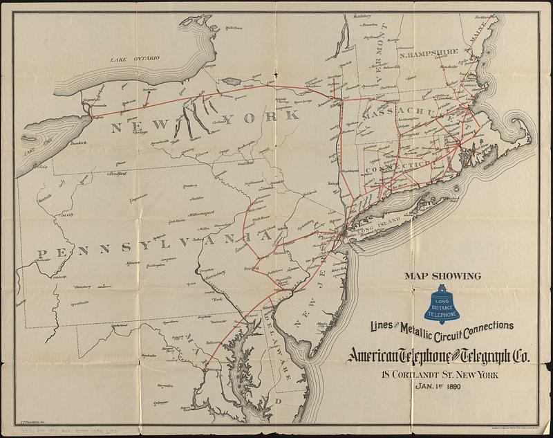
Map showing long distance telephone lines and metallic circuit connections
Viewing image 1 of 2
Next >
Map showing long distance telephone lines and metallic circuit connections
×
Next
Item Information
Title:
Map showing long distance telephone lines and metallic circuit connections
Title (alt.):
Long distance telephone American Telephone and Telegraph Company
Cartographer:
Denison, S. P.
Lithographer:
Welcke, Robert A.
Publisher:
American Telephone and Telegraph Company
Name on Item:
S.P. Denison del.
Date:
1890
Format:
Maps/Atlases
Location:
Boston Public Library
Norman B. Leventhal Map Center
Collection (local):
Norman B. Leventhal Map Center Collection
Subjects:
Northeastern States--Maps
Telephone lines--Northeastern States--Maps
Places:
Northeastern United States
(area)
Extent:
1 map : color ; 54 x 38 cm, folded to 18 x 10 cm
Permalink:
https://ark.digitalcommonwealth.org/ark:/50959/5999qk46q
Terms of Use:
No known copyright restrictions.
No known restrictions on use.
Publisher:
New York : American Telephone and Telegraph Co.
Scale:
Scale approximately 1:1,300,000
Language:
English
Notes:
Oriented with north to the upper left.
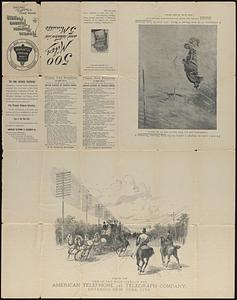
On verso: text; list of public pay stations; View of one of the main lines of the American Telephone and Telegraph Company, entering New York City; and illustration of the great blizzard of March, 1888.
Identifier:
06_01_017394
06_01_017394B
Call #:
G3716.P94 1890 .A44
Barcode:
39999085966073
show more...
View MODS XML
More Like This
Carte pour servir à l'itinéraire pittoresque du fleuve Hudson et ...
The city of New York as laid out by the Commissioners with the ...
The health and pleasure resorts of New York and New England, the ...
Map of Cleveland & Toledo Rail Road, with its connections
Find More Like This >>
Tools
Share
Facebook
Pinterest
X
Reddit
Tumblr
Email
Copy link
Add to Folder
Questions/Comments
Cite This Item
IIIF Manifest
Downloads
Primary (full resolution, uncompressed)
(TIF, multi-file ZIP, 132 MB)
Large (full resolution)
(JPEG, multi-file ZIP, 1.17 MB)
Medium
(JPEG, multi-file ZIP, 185 KB)