Skip to search
Skip to main content
Digital Commonwealth
Sign Up / Log In
Search for
Search
Search
Search
Basic
Advanced
Explore
Map
Collections
Institutions
Formats
For Educators
Primary Source Sets
Lesson Plans
Using Primary Sources
Searching Digital Commonwealth
For Institutions
Join Digital Commonwealth
Conferences, Trainings, & Events
How to Contribute Collections
Digitization Services
Board & Committees
Frequently Asked Questions
About
About Digital Commonwealth
News & Announcements
Copyright & Terms of Use
Harmful Content Statement
Partners
API
Contact Us
Boston Public Library
Norman B. Leventhal Map Center Collection
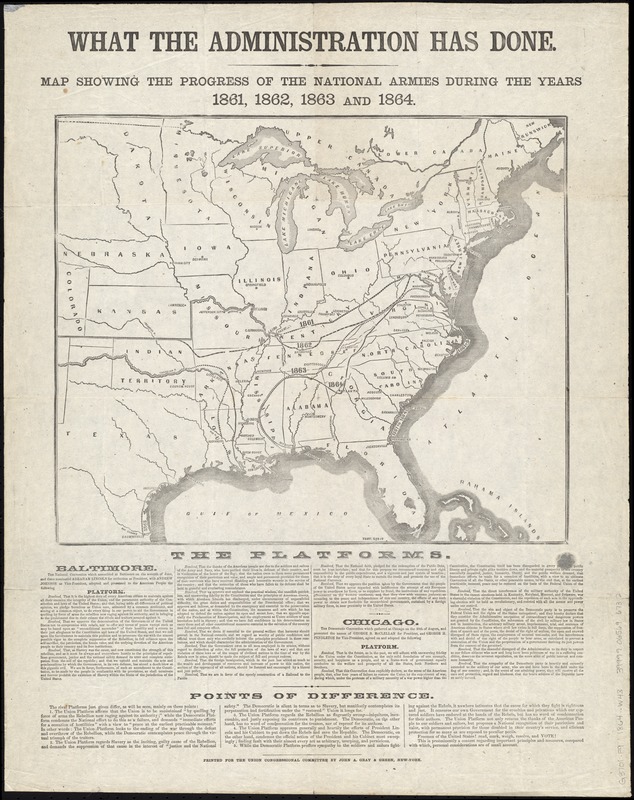
What the administration has done : map showing the progress of the national armies during the years 1861, 1862, 1863, and 1864
What the administration has done
×
Item Information
Title:
What the administration has done : map showing the progress of the national armies during the years 1861, 1862, 1863, and 1864
Date:
[1864]
Format:
Maps/Atlases
Location:
Boston Public Library
Norman B. Leventhal Map Center
Collection (local):
Norman B. Leventhal Map Center Collection
Subjects:
Republican National Committee (U.S.)
Campaign literature, 1864--Republican
United States--Politics and government--1861-1865
United States--History--Civil War, 1861-1865--Maps
Places:
Extent:
1 map ; 33 x 40 cm, on sheet 61 x 48 cm
Permalink:
https://ark.digitalcommonwealth.org/ark:/50959/4m90fn47c
Terms of Use:
No known copyright restrictions.
No known restrictions on use.
Publisher:
New-York : Printed for the Union Congressional Committee by John A. Gray & Green,
Scale:
Scale approximately 1:8,250,000
Language:
English
Notes:
Includes text describing points of difference in Republican and Democratic platforms.
Notes (date):
This date is inferred.
Identifier:
06_01_012254
Call #:
G3701.F9 1864 .W43
Barcode:
39999065696732
show more...
View MODS XML
More Like This
Lloyd's new political chart, 1861 : with a map of the United ...
Bacon's Map of the seat of war in Virginia : showing minutely the ...
Bacon's military map of the United States shewing the forts & ...
Bacon's steel plate map of the American states north & south : ...
Find More Like This >>
Tools
Share
Facebook
Pinterest
X
Reddit
Tumblr
Email
Copy link
Add to Folder
Questions/Comments
Cite This Item
IIIF Manifest
Downloads
Primary (full resolution, uncompressed)
(TIF, 114 MB)
Large (full resolution)
(JPEG, 9.55 MB)
Medium
(JPEG, 204 KB)