Skip to search
Skip to main content
Digital Commonwealth
Sign Up / Log In
Search for
Search
Search
Search
Basic
Advanced
Explore
Map
Collections
Institutions
Formats
For Educators
Primary Source Sets
Lesson Plans
Using Primary Sources
Searching Digital Commonwealth
For Institutions
Join Digital Commonwealth
Conferences, Trainings, & Events
How to Contribute Collections
Digitization Services
Board & Committees
Frequently Asked Questions
About
About Digital Commonwealth
News & Announcements
Copyright & Terms of Use
Harmful Content Statement
Partners
API
Contact Us
Boston Public Library
Norman B. Leventhal Map Center Collection
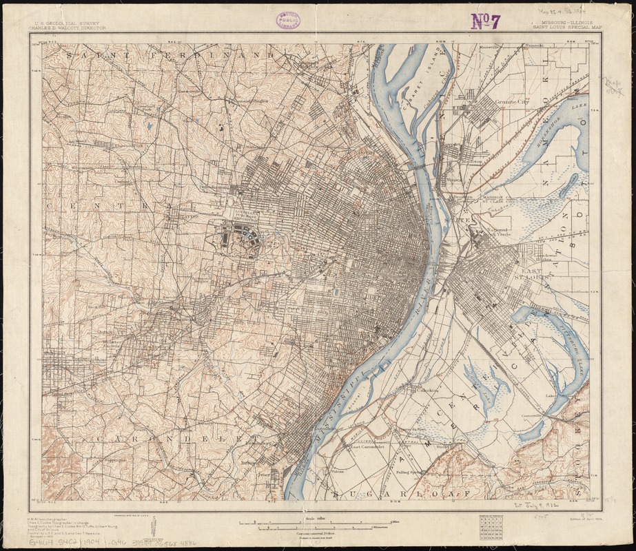
Missouri-Illinois, Saint Louis special map
Missouri-Illinois, Saint Louis special map
×
Item Information
Title:
Missouri-Illinois, Saint Louis special map
Title (alt.):
Saint Louis special map
Creator:
Geological Survey (U.S.)
Name on Item:
U.S. Geological Survey ; H.M. Wilson, geographer ; Chas. E. Cooke, topographer in charge ; topography by Chas. E. Cooke, Wm. O. Tufts, Gilbert Young and the City of St. Louis ; control by U.S.C. and G.S and Geo. T. Hawkins.
Date:
1904
Format:
Maps/Atlases
Location:
Boston Public Library
Norman B. Leventhal Map Center
Collection (local):
Norman B. Leventhal Map Center Collection
Subjects:
Saint Louis (Mo.)--Maps
Places:
Saint Louis
Extent:
1 map : col. ; 39 x 47 cm.
Permalink:
https://ark.digitalcommonwealth.org/ark:/50959/4m90fb17s
Terms of Use:
No known copyright restrictions.
No known restrictions on use.
Publisher:
[Washington, D.C.] : The Survey
Scale:
Scale 1:62,500
Language:
English
Notes:
Relief shown by contours and spot heights.
Text and ill. on verso.
Identifier:
06_01_011340
Call #:
G4164.S4C2 1904 .G46
Barcode:
39999065684886
show more...
View MODS XML
More Like This
Campbell's revised guide map of St. Louis
Map of city of St. Louis and suburbs
Map of St. Louis city & county : prepared for City Plan Report of ...
Map of the harbor of St. Louis, Mississippi River, Oct. 1837
Find More Like This >>
Tools
Share
Facebook
Pinterest
X
Reddit
Tumblr
Email
Copy link
Add to Folder
Questions/Comments
Cite This Item
IIIF Manifest
Downloads
Primary (full resolution, uncompressed)
(TIF, 83 MB)
Large (full resolution)
(JPEG, 6.97 MB)
Medium
(JPEG, 356 KB)
GeoTIFF (georeferenced)
(TIF, 105 MB)