Skip to search
Skip to main content
Digital Commonwealth
Sign Up / Log In
Search for
Search
Search
Search
Basic
Advanced
Explore
Map
Collections
Institutions
Formats
For Educators
Primary Source Sets
Lesson Plans
Using Primary Sources
Searching Digital Commonwealth
For Institutions
Join Digital Commonwealth
Conferences, Trainings, & Events
How to Contribute Collections
Digitization Services
Board & Committees
Frequently Asked Questions
About
About Digital Commonwealth
News & Announcements
Copyright & Terms of Use
Harmful Content Statement
Partners
API
Contact Us
Boston Public Library
Norman B. Leventhal Map Center Collection
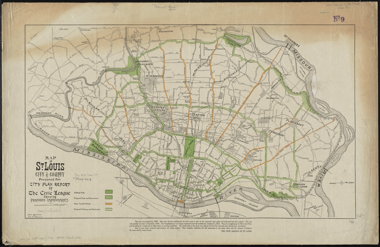
Map of St. Louis city & county : prepared for City Plan Report of The Civic League showing proposed improvements
Map of St. Louis city & county
×
Item Information
Title:
Map of St. Louis city & county : prepared for City Plan Report of The Civic League showing proposed improvements
Title (alt.):
Map of Saint Louis city and county
Creator:
Travilla, James C.
Name on Item:
map prepared by Jas. C. Travilla.
Date:
1907
Format:
Maps/Atlases
Location:
Boston Public Library
Norman B. Leventhal Map Center
Collection (local):
Norman B. Leventhal Map Center Collection
Subjects:
Parks--Missouri--Saint Louis--Maps
Parkways--Missouri--Saint Louis--Maps
Saint Louis (Mo.)--Maps
Saint Louis County (Mo.)--Maps
Places:
Saint Louis (county)
Extent:
1 map : col. ; 44 x 75 cm.
Permalink:
https://ark.digitalcommonwealth.org/ark:/50959/4m90f9992
Terms of Use:
No known copyright restrictions.
No known restrictions on use.
Publisher:
St. Louis, Mo : Civic League of St. Louis
Scale:
Scale [ca. 1:70,500]
Language:
English
Notes:
Shows existing and proposed parks and reservations; also, main travelled roads and proposed parkways and boulevards.
Oriented with north to the right.
In lower margin: This map was prepared in 1907 ... The Civic League of St. Louis.
Identifier:
06_01_011238
Call #:
G4163.S35 1907 .T73
Barcode:
39999065682153
show more...
View MODS XML
More Like This
Map of city of St. Louis and suburbs
Campbell's revised guide map of St. Louis
Map of the harbor of St. Louis, Mississippi River, Oct. 1837
Missouri-Illinois, Saint Louis special map
Find More Like This >>
Tools
Share
Facebook
Pinterest
X
Reddit
Tumblr
Email
Copy link
Add to Folder
Questions/Comments
Cite This Item
IIIF Manifest
Downloads
Primary (full resolution, uncompressed)
(TIF, 218 MB)
Large (full resolution)
(JPEG, 18.3 MB)
Medium
(JPEG, 345 KB)