Skip to search
Skip to main content
Digital Commonwealth
Sign Up / Log In
Search for
Search
Search
Search
Basic
Advanced
Explore
Map
Collections
Institutions
Formats
For Educators
Primary Source Sets
Lesson Plans
Using Primary Sources
Searching Digital Commonwealth
For Institutions
Join Digital Commonwealth
Conferences, Trainings, & Events
How to Contribute Collections
Digitization Services
Board & Committees
Frequently Asked Questions
About
About Digital Commonwealth
News & Announcements
Copyright & Terms of Use
Harmful Content Statement
Partners
API
Contact Us
Boston Public Library
Norman B. Leventhal Map Center Collection
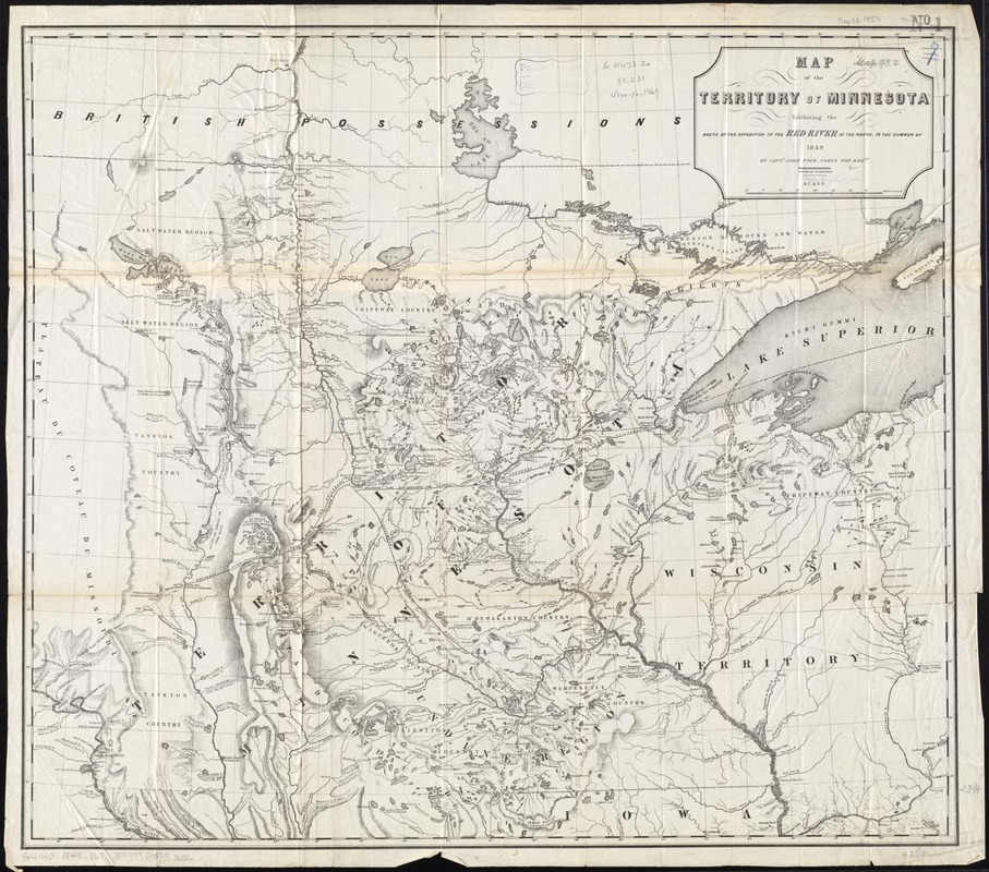
Map of the territory of Minnesota exhibiting the route of the expedition to the Red River of the north, in the summer of 1849
Map of the territory of Minnesota exhibiting the route of the expedition to the Red River of the north, in the summer of 1849
×
Item Information
Title:
Map of the territory of Minnesota exhibiting the route of the expedition to the Red River of the north, in the summer of 1849
Creator:
Pope, John, 1822-1892
Name on Item:
by Captn. John Pope, Corps Top. Engrs. ; drawn by P. S. Morawski.
Date:
[1849]
Format:
Maps/Atlases
Location:
Boston Public Library
Norman B. Leventhal Map Center
Collection (local):
Norman B. Leventhal Map Center Collection
Subjects:
Minnesota--Discovery and exploration--Maps
Places:
Minnesota
Extent:
1 map ; 61 x 70 cm
Permalink:
https://ark.digitalcommonwealth.org/ark:/50959/4m90f9746
Terms of Use:
No known copyright restrictions.
No known restrictions on use.
Publisher:
[Washington, D.C.] : [publisher not identified]
Scale:
Scale approximately 1:1,230,000
Language:
English
Notes:
Relief shown by hachures and spot heights.
Gives both Indian and later place names.
Shows "Proposed line of grants for railroads."
Notes (date):
This date is inferred.
Identifier:
06_01_011277
Call #:
G4140 1849 .P67
Barcode:
39999065683656
LCCN:
74696065
show more...
View MODS XML
More Like This
Map of the route passed over by an expedition into the Indian ...
The 100th anniversary map of Abraham Lincoln's visit to ...
1630 shoreline
1879. Progress map of the U.S. Geographical Surveys west of the ...
Find More Like This >>
Tools
Share
Facebook
Pinterest
X
Reddit
Tumblr
Email
Copy link
Add to Folder
Questions/Comments
Cite This Item
IIIF Manifest
Downloads
Primary (full resolution, uncompressed)
(TIF, 71.6 MB)
Large (full resolution)
(JPEG, 6.01 MB)
Medium
(JPEG, 310 KB)