Skip to search
Skip to main content
Digital Commonwealth
Sign Up / Log In
Search for
Search
Search
Search
Basic
Advanced
Explore
Map
Collections
Institutions
Formats
For Educators
Primary Source Sets
Lesson Plans
Using Primary Sources
Searching Digital Commonwealth
For Institutions
Join Digital Commonwealth
Conferences, Trainings, & Events
How to Contribute Collections
Digitization Services
Board & Committees
Frequently Asked Questions
About
About Digital Commonwealth
News & Announcements
Copyright & Terms of Use
Harmful Content Statement
Partners
API
Contact Us
Boston Public Library
Norman B. Leventhal Map Center Collection
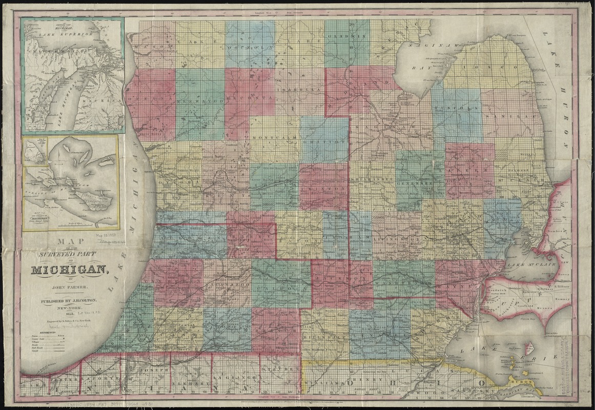
Map of the surveyed part of Michigan
Map of the surveyed part of Michigan
×
Item Information
Title:
Map of the surveyed part of Michigan
Creator:
Farmer, John, 1789-1838
Name on Item:
by John Farmer ; engraved by S. Stiles & Co.
Date:
1853
Format:
Maps/Atlases
Location:
Boston Public Library
Norman B. Leventhal Map Center
Collection (local):
Norman B. Leventhal Map Center Collection
Subjects:
Michigan--Maps
Places:
Michigan
Extent:
1 map : hand col. ; 57 x 83 cm.
Permalink:
https://ark.digitalcommonwealth.org/ark:/50959/4m90f7930
Terms of Use:
No known copyright restrictions.
No known restrictions on use.
Publisher:
New-York : J.H. Colton
Scale:
Scale [ca. 1:540,000]
Language:
English
Notes:
Covers southern Michigan.
"Entered according to act of Congress in the year 1852 by J.H. Colton & Co. ..."
Prime meridians: Greenwich and Washington.
Insets: Northern part of Michigan -- Map of the Straits of Mackinaw.
Identifier:
06_01_011163
Call #:
G4110 1854 .F37
Barcode:
39999065682831
show more...
View MODS XML
More Like This
The great north woods tourist and fishing district of Wisconsin : ...
A map of part of the N:W: Territory of the United States : ...
Map of the states of Ohio, Indiana and Illinois with the settled ...
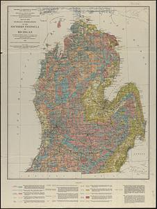
Map of the surface formations of the southern peninsula of Michigan
Find More Like This >>
Tools
Share
Facebook
Pinterest
X
Reddit
Tumblr
Email
Copy link
Add to Folder
Questions/Comments
Cite This Item
IIIF Manifest
Downloads
Primary (full resolution, uncompressed)
(TIF, 247 MB)
Large (full resolution)
(JPEG, 20.7 MB)
Medium
(JPEG, 412 KB)
GeoTIFF (georeferenced)
(TIF, 321 MB)