Skip to search
Skip to main content
Digital Commonwealth
Sign Up / Log In
Search for
Search
Search
Search
Basic
Advanced
Explore
Map
Collections
Institutions
Formats
For Educators
Primary Source Sets
Lesson Plans
Using Primary Sources
Searching Digital Commonwealth
For Institutions
Join Digital Commonwealth
Conferences, Trainings, & Events
How to Contribute Collections
Digitization Services
Board & Committees
Frequently Asked Questions
About
About Digital Commonwealth
News & Announcements
Copyright & Terms of Use
Harmful Content Statement
Partners
API
Contact Us
Boston Public Library
Norman B. Leventhal Map Center Collection
/
Urban Maps (Collection of Distinction)
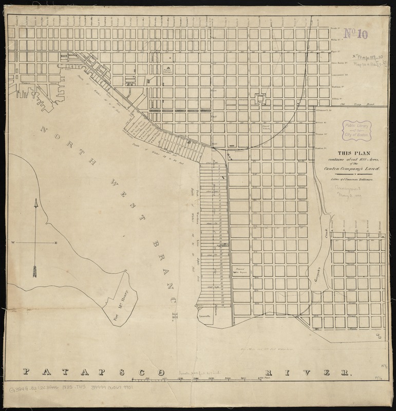
This plan contains about 1000 acres, of the Canton Company's Land
This plan contains about 1000 acres, of the Canton Companys Land
×
Item Information
Title:
This plan contains about 1000 acres, of the Canton Company's Land
Lithographer:
Penniman, John, approximately 1817-1850
Name on Item:
litho. of J. Penniman.
Date:
[1835]
Format:
Maps/Atlases
Location:
Boston Public Library
Norman B. Leventhal Map Center
Collection (local):
Norman B. Leventhal Map Center Collection
Subjects:
Railroads--Maryland--Baltimore--Maps
Real property--Maryland--Baltimore--Maps
Canton (Baltimore, Md.)--Maps
Places:
Baltimore Independent City (county)
>
Baltimore
Baltimore Independent City (county)
>
Canton
Extent:
1 map ; 49 x 51 cm.
Permalink:
https://ark.digitalcommonwealth.org/ark:/50959/4m90f431c
Terms of Use:
No known copyright restrictions.
No known restrictions on use.
Publisher:
S.l : s.n.
Scale:
Scale [ca. 1:7,200]
Language:
English
Notes:
Shows the Canton and Canton Industrial Area of Baltimore.
From Report on the objects, condition and prospects of the Canton Company of Baltimore.
Notes (date):
This date is inferred.
Identifier:
06_01_010865
Call #:
G3844.B2:2C3G46 1835 .T45
Barcode:
39999065679951
show more...
View MODS XML
More Like This
The 100th anniversary map of Abraham Lincoln's visit to ...
1630 shoreline
1879. Progress map of the U.S. Geographical Surveys west of the ...
1903 Map of Salem and surrounding places
Find More Like This >>
Tools
Share
Facebook
Pinterest
X
Reddit
Tumblr
Email
Copy link
Add to Folder
Questions/Comments
Cite This Item
IIIF Manifest
Downloads
Primary (full resolution, uncompressed)
(TIF, 100 MB)
Large (full resolution)
(JPEG, 8.42 MB)
Medium
(JPEG, 194 KB)