Skip to search
Skip to main content
Digital Commonwealth
Sign Up / Log In
Search for
Search
Search
Search
Basic
Advanced
Explore
Map
Collections
Institutions
Formats
For Educators
Primary Source Sets
Lesson Plans
Using Primary Sources
Searching Digital Commonwealth
For Institutions
Join Digital Commonwealth
Conferences, Trainings, & Events
How to Contribute Collections
Digitization Services
Board & Committees
Frequently Asked Questions
About
About Digital Commonwealth
News & Announcements
Copyright & Terms of Use
Harmful Content Statement
Partners
API
Contact Us
Boston Public Library
Norman B. Leventhal Map Center Collection
/
Urban Maps (Collection of Distinction)
/
Boston and New England Maps (Collection of Distinction)
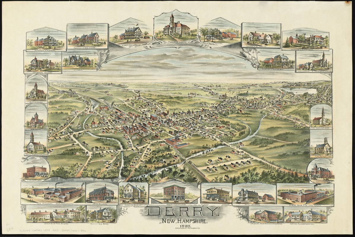
Derry, New Hampshire
Derry, New Hampshire
×
Item Information
Title:
Derry, New Hampshire
Creator:
Bailey, O. H. (Oakley Hoopes), 1843-1947
Date:
1898
Format:
Maps/Atlases
Location:
Boston Public Library
Norman B. Leventhal Map Center
Collection (local):
Norman B. Leventhal Map Center Collection
Subjects:
Derry (N.H.)--Maps
Derry (N.H.)--Aerial views
Places:
Rockingham (county)
>
Derry
Extent:
1 view : col. ; 48 x 68 cm.
Permalink:
https://ark.digitalcommonwealth.org/ark:/50959/4m90f426h
Terms of Use:
No known copyright restrictions.
No known restrictions on use.
Publisher:
Derry, N.H : Charles Bartlett
Scale:
Not drawn to scale
Language:
English
Notes:
Bird's-eye view from the southeast.
Includes 29 vignettes of buildings.
Identifier:
06_01_010859
Call #:
G3744.D49A3 1898 .B35
Barcode:
39999065678086
show more...
View MODS XML
More Like This
Derry Depot, N.H : Rockingham County : 1887
The 100th anniversary map of Abraham Lincoln's visit to ...
1630 shoreline
1879. Progress map of the U.S. Geographical Surveys west of the ...
Find More Like This >>
Tools
Share
Facebook
Pinterest
X
Reddit
Tumblr
Email
Copy link
Add to Folder
Questions/Comments
Cite This Item
IIIF Manifest
Downloads
Primary (full resolution, uncompressed)
(TIF, 141 MB)
Large (full resolution)
(JPEG, 11.9 MB)
Medium
(JPEG, 405 KB)