Skip to search
Skip to main content
Digital Commonwealth
Sign Up / Log In
Search for
Search
Search
Search
Basic
Advanced
Explore
Map
Collections
Institutions
Formats
For Educators
Primary Source Sets
Lesson Plans
Using Primary Sources
Searching Digital Commonwealth
For Institutions
Join Digital Commonwealth
Conferences, Trainings, & Events
How to Contribute Collections
Digitization Services
Board & Committees
Frequently Asked Questions
About
About Digital Commonwealth
News & Announcements
Copyright & Terms of Use
Harmful Content Statement
Partners
API
Contact Us
Boston Public Library
Norman B. Leventhal Map Center Collection
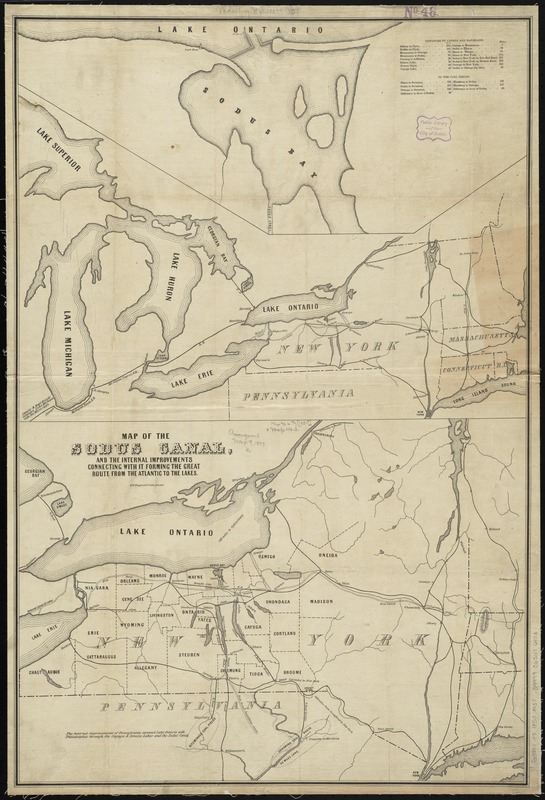
Map of the Sodus Canal, and the internal improvements connecting with it forming the great route from the Atlantic to the Lakes
Map of the Sodus Canal, and the internal improvements connecting with it forming the great route from the Atlantic to the Lakes
×
Item Information
Title:
Map of the Sodus Canal, and the internal improvements connecting with it forming the great route from the Atlantic to the Lakes
Date:
[1850–1859]
Format:
Maps/Atlases
Location:
Boston Public Library
Norman B. Leventhal Map Center
Collection (local):
Norman B. Leventhal Map Center Collection
Subjects:
Canals--New York (State)--Maps
Sodus Bay (N.Y.)--Maps
New York (State)--Maps
Places:
Wayne (county)
>
Sodus Bay
Extent:
1 map ; 85 x 57 cm.
Permalink:
https://ark.digitalcommonwealth.org/ark:/50959/4m90f2662
Terms of Use:
No known copyright restrictions.
No known restrictions on use.
Publisher:
Boston : B.W. Thayer & Co. lith.
Scale:
Scale [ca. 1,100,000]
Language:
English
Notes:
Shows canals in New York and surrounding states, including the proposed (but not built) Sodus Canal.
Relief shown by hachures.
Ancillary maps: [Great Lakes] -- [Sodus Bay]
Includes tables of distances.
Notes (date):
This date is inferred.
Identifier:
06_01_010725
Call #:
G3801.P5 1850 .M37
Barcode:
39999065676403
show more...
View MODS XML
More Like This
Map of the State of New-York : showing its water and rail road ...
Map of the northern & eastern section of the United States
Connecticut with portions of New York & Rhode Island
E.P. Dutton & Co.'s railroad, steam boat & stage route map of New ...
Find More Like This >>
Tools
Share
Facebook
Pinterest
X
Reddit
Tumblr
Email
Copy link
Add to Folder
Questions/Comments
Cite This Item
IIIF Manifest
Downloads
Primary (full resolution, uncompressed)
(TIF, 191 MB)
Large (full resolution)
(JPEG, 16 MB)
Medium
(JPEG, 169 KB)