Skip to search
Skip to main content
Digital Commonwealth
Sign Up / Log In
Search for
Search
Search
Search
Basic
Advanced
Explore
Map
Collections
Institutions
Formats
For Educators
Primary Source Sets
Lesson Plans
Using Primary Sources
Searching Digital Commonwealth
For Institutions
Join Digital Commonwealth
Conferences, Trainings, & Events
How to Contribute Collections
Digitization Services
Board & Committees
Frequently Asked Questions
About
About Digital Commonwealth
News & Announcements
Copyright & Terms of Use
Harmful Content Statement
Partners
API
Contact Us
Boston Public Library
Norman B. Leventhal Map Center Collection
/
American Revolutionary War-Era Maps (Collection of Distinction)
/
Boston and New England Maps (Collection of Distinction)
/
Maritime Charts and Atlases (Collection of Distinction)
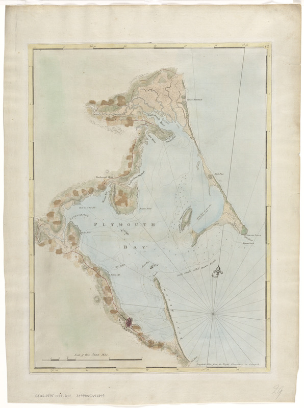
Chart of Plymouth Bay
Chart of Plymouth Bay
×
Item Information
Title:
Chart of Plymouth Bay
Creator:
Des Barres, Joseph F. W. (Joseph Frederick Wallet), 1722-1824
Date:
[1770–1779]
Format:
Maps/Atlases
Location:
Boston Public Library
Norman B. Leventhal Map Center
Collection (local):
Norman B. Leventhal Map Center Collection
Subjects:
Nautical charts--Massachusetts--Plymouth Bay--Early works to 1800
Plymouth Bay (Mass.)--Maps--Early works to 1800
Places:
Massachusetts
>
Plymouth (county)
>
Plymouth Bay
Extent:
1 chart : col. ; 67 x 49 cm.
Permalink:
https://ark.digitalcommonwealth.org/ark:/50959/3f463952c
Terms of Use:
No known copyright restrictions.
No known restrictions on use.
Publisher:
London : J.F.W. Des Barres
Edition:
2nd state.
Scale:
Scale [ca. 1:24,000]
Language:
English
Notes:
Relief shown by hachures. Depths shown by soundings.
Appears in the author's Atlantic Neptune.
Variant of entry 960 in LC Maps of North America, 1750-1789.
"12" engraved in small oval in upper right corner of the border; lacks imprint.
Notes (date):
This date is inferred.
Identifier:
06_01_008396
Call #:
G3762.P6P5 1777 .D47
Barcode:
39999065646349
show more...
View MODS XML
More Like This
Chart of Plymouth Bay
Chart of Plymouth Bay
The 100th anniversary map of Abraham Lincoln's visit to ...
1630 shoreline
Find More Like This >>
Tools
Share
Facebook
Pinterest
X
Reddit
Tumblr
Email
Copy link
Add to Folder
Questions/Comments
Cite This Item
IIIF Manifest
Downloads
Primary (full resolution, uncompressed)
(TIF, 61.2 MB)
Large (full resolution)
(JPEG, 5.14 MB)
Medium
(JPEG, 136 KB)