Skip to search
Skip to main content
Digital Commonwealth
Sign Up / Log In
Search for
Search
Search
Search
Basic
Advanced
Explore
Map
Collections
Institutions
Formats
For Educators
Primary Source Sets
Lesson Plans
Using Primary Sources
Searching Digital Commonwealth
For Institutions
Join Digital Commonwealth
Conferences, Trainings, & Events
How to Contribute Collections
Digitization Services
Board & Committees
Frequently Asked Questions
About
About Digital Commonwealth
News & Announcements
Copyright & Terms of Use
Harmful Content Statement
Partners
API
Contact Us
Boston Public Library
Norman B. Leventhal Map Center Collection
Zoning map of town-planning area of Tokyo - 1925
Zoning map of town-planning area of Tokyo - 1925
×
Item Information
Title:
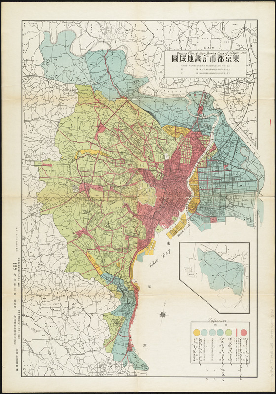
Zoning map of town-planning area of Tokyo - 1925
Date:
[1928]
Format:
Maps/Atlases
Location:
Boston Public Library
Norman B. Leventhal Map Center
Collection (local):
Norman B. Leventhal Map Center Collection
Subjects:
Zoning--Japan--Tokyo--Maps
Tokyo (Japan)--Maps
Places:
Japan
>
Tokyo
Extent:
1 map : color ; 73 x 50 cm
Permalink:
https://ark.digitalcommonwealth.org/ark:/50959/3f463848k
Terms of Use:
No known copyright restrictions.
No known restrictions on use.
Publisher:
[Japan] : [publisher not identified]
Scale:
Scale 1:20,000
Language:
Japanese
Notes:
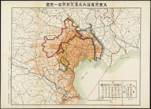
Part of a collection of 7 maps of Tokyo.
Translated title, legend and some place names handwritten in ink.
Conservation of this piece was funded by Arend Sluis and Mark Mulligan.
Notes (date):
This date is inferred.
Identifier:
06_01_014542
Call #:
G7964.T7 1928 .C65
Barcode:
39999065703934
show more...
View MODS XML
More Like This
Ansei kaisei Oedo ōezu = Map of Jeddo
District within fire limit of Tokyo - 1928
Gas and water-supply in greater Tokyo - 1928
Showing rental values in greater Tokyo - 1926
Find More Like This >>
Tools
Share
Facebook
Pinterest
X
Reddit
Tumblr
Email
Copy link
Add to Folder
Questions/Comments
Cite This Item
IIIF Manifest
Downloads
Primary (full resolution, uncompressed)
(TIF, 178 MB)
Large (full resolution)
(JPEG, 14.9 MB)
Medium
(JPEG, 236 KB)