Skip to search
Skip to main content
Digital Commonwealth
Sign Up / Log In
Search for
Search
Search
Search
Basic
Advanced
Explore
Map
Collections
Institutions
Formats
For Educators
Primary Source Sets
Lesson Plans
Using Primary Sources
Searching Digital Commonwealth
For Institutions
Join Digital Commonwealth
Conferences, Trainings, & Events
How to Contribute Collections
Digitization Services
Board & Committees
Frequently Asked Questions
About
About Digital Commonwealth
News & Announcements
Copyright & Terms of Use
Harmful Content Statement
Partners
API
Contact Us
Boston Public Library
Norman B. Leventhal Map Center Collection
/
Urban Maps (Collection of Distinction)
/
Boston and New England Maps (Collection of Distinction)
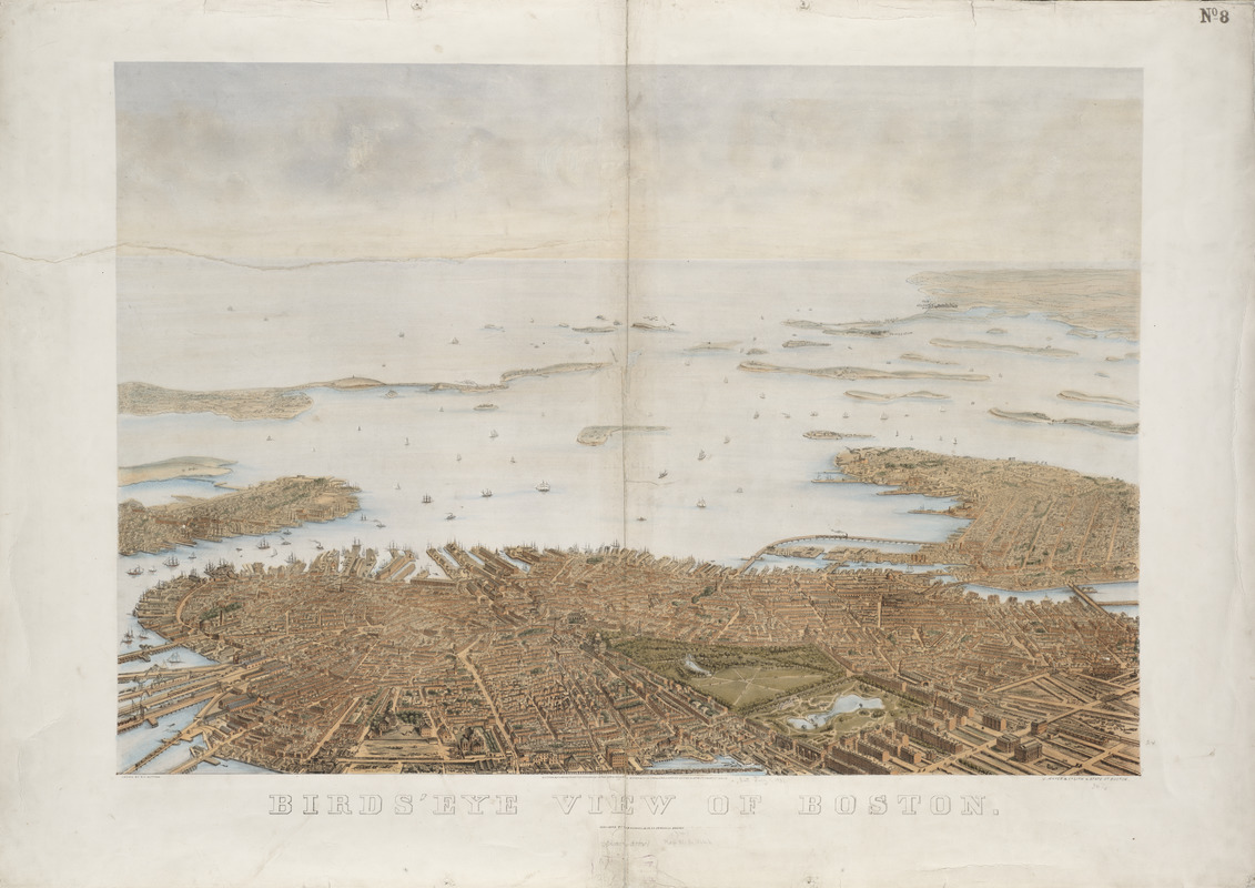
Bird's eye view of Boston
Birds eye view of Boston
×
Item Information
Title:
Bird's eye view of Boston
Title (alt.):
Birds' eye view of Boston
Creator:
Nutting, B. F. (Benjamin Franklin), 1803?-1887
Contributor:
J. Mayer & Co
Name on Item:
drawn by B.F. Nutting
Date:
1866
Format:
Maps/Atlases
Location:
Boston Public Library
Norman B. Leventhal Map Center
Collection (local):
Norman B. Leventhal Map Center Collection
Subjects:
Boston (Mass.)--Aerial views
Places:
Suffolk (county)
>
Boston
Extent:
1 view : col. ; 61 x 87 cm.
Permalink:
https://ark.digitalcommonwealth.org/ark:/50959/3f4633656
Terms of Use:
No known copyright restrictions.
No known restrictions on use.
Publisher:
Boston, Mass : B.B. Russell & Co.
Scale:
Not drawn to scale
Language:
English
Notes:
Bird's-eye view.
Identifier:
06_01_001283
Barcode:
39999058996446
show more...
View MODS XML
More Like This
Ausicht von Boston : nach der natur aufgenommen
Balloon view, Cape Ann to Boston
Balloon view Provincetown to Boston
Balloon view--Boston Harbor
Find More Like This >>
Tools
Share
Facebook
Pinterest
X
Reddit
Tumblr
Email
Copy link
Add to Folder
Questions/Comments
Cite This Item
IIIF Manifest
Downloads
Primary (full resolution, uncompressed)
(TIF, 240 MB)
Large (full resolution)
(JPEG, 20.1 MB)
Medium
(JPEG, 264 KB)