Skip to search
Skip to main content
Digital Commonwealth
Sign Up / Log In
Search for
Search
Search
Search
Basic
Advanced
Explore
Map
Collections
Institutions
Formats
For Educators
Primary Source Sets
Lesson Plans
Using Primary Sources
Searching Digital Commonwealth
For Institutions
Join Digital Commonwealth
Conferences, Trainings, & Events
How to Contribute Collections
Digitization Services
Board & Committees
Frequently Asked Questions
About
About Digital Commonwealth
News & Announcements
Copyright & Terms of Use
Harmful Content Statement
Partners
API
Contact Us
Boston Public Library
Norman B. Leventhal Map Center Collection
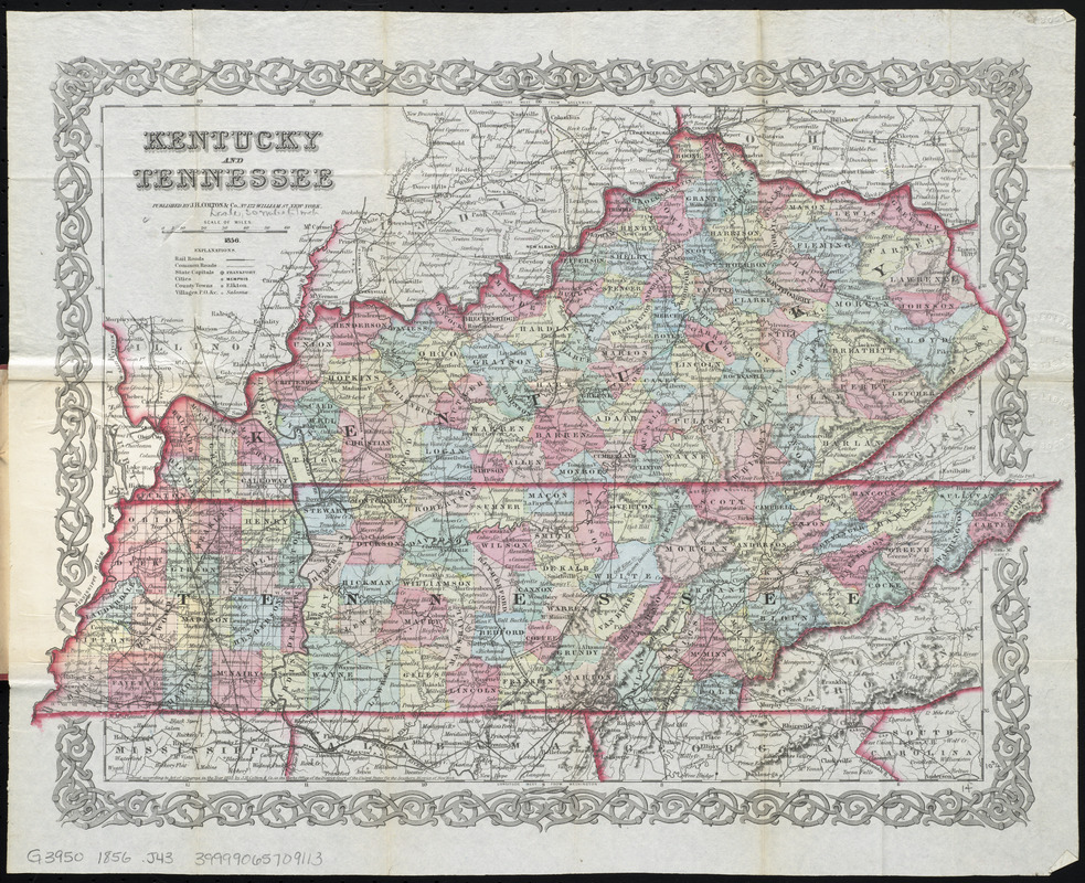
Kentucky and Tennessee
Kentucky and Tennessee
×
Item Information
Title:
Kentucky and Tennessee
Title (alt.):
Map of Kentucky and Tennessee
Creator:
J.H. Colton & Co
Date:
1856
Format:
Maps/Atlases
Location:
Boston Public Library
Norman B. Leventhal Map Center
Collection (local):
Norman B. Leventhal Map Center Collection
Subjects:
Kentucky--Maps
Tennessee--Maps
Places:
Tennessee
Kentucky
Extent:
1 map : hand col. ; 27 x 43 cm., folded in cover 13 x 9 cm.
Permalink:
https://ark.digitalcommonwealth.org/ark:/50959/3f463281c
Terms of Use:
No known copyright restrictions.
No known restrictions on use.
Publisher:
New York : J. H. Colton & Co.
Scale:
Scale [ca. 1:1,900,800]
Language:
English
Notes:
Relief shown by hachures.
"Entered according to Act of Congress in the year 1855, by J.H. Colton & Co. ..."
Prime meridians: Greenwich and Washington.
Identifier:
06_01_010706
Call #:
G3950 1856 .J43
Barcode:
39999065709113
show more...
View MODS XML
More Like This
Kentucky and Tennessee
Map of Kentucky and Tennessee
Post route map of the states of Kentucky and Tennessee showing ...
Post route map of the states of Kentucky and Tennessee showing ...
Find More Like This >>
Tools
Share
Facebook
Pinterest
X
Reddit
Tumblr
Email
Copy link
Add to Folder
Questions/Comments
Cite This Item
IIIF Manifest
Downloads
Primary (full resolution, uncompressed)
(TIF, 90.1 MB)
Large (full resolution)
(JPEG, 7.57 MB)
Medium
(JPEG, 438 KB)
GeoTIFF (georeferenced)
(TIF, 128 MB)