Skip to search
Skip to main content
Digital Commonwealth
Sign Up / Log In
Search for
Search
Search
Search
Basic
Advanced
Explore
Map
Collections
Institutions
Formats
For Educators
Primary Source Sets
Lesson Plans
Using Primary Sources
Searching Digital Commonwealth
For Institutions
Join Digital Commonwealth
Conferences, Trainings, & Events
How to Contribute Collections
Digitization Services
Board & Committees
Frequently Asked Questions
About
About Digital Commonwealth
News & Announcements
Copyright & Terms of Use
Harmful Content Statement
Partners
API
Contact Us
Boston Public Library
Norman B. Leventhal Map Center Collection
/
Maritime Charts and Atlases (Collection of Distinction)
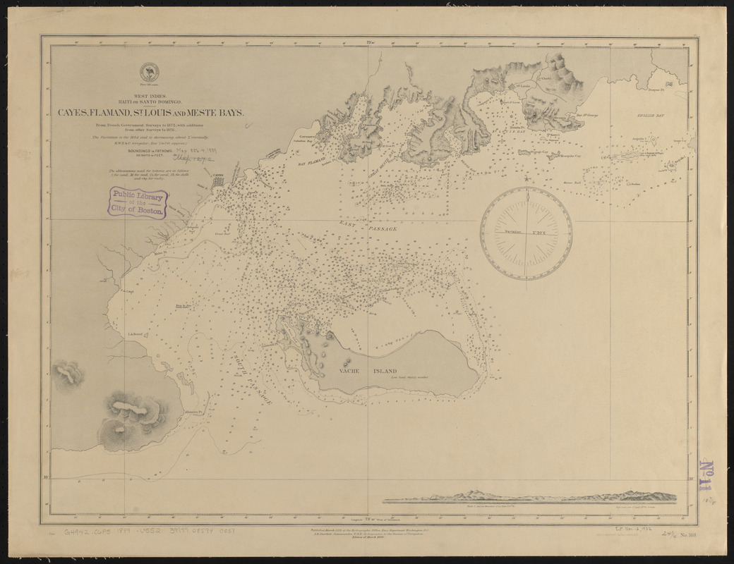
West Indies, Haïti or St. Domingo, Gonaïves Bay : from a French survey, 1847
West Indies, Haïti or St. Domingo, Gonaïves Bay
×
Item Information
Title:
West Indies, Haïti or St. Domingo, Gonaïves Bay : from a French survey, 1847
Title (alt.):
Gonaïves Bay
Issuing body:
United States. Hydrographic Office
Date:
1882
Format:
Maps/Atlases
Location:
Boston Public Library
Norman B. Leventhal Map Center
Collection (local):
Norman B. Leventhal Map Center Collection
Subjects:
Nautical charts--Haiti--Gonaïves Bay
Nautical charts--Haiti--Hospital Bay
Nautical charts--Haiti--Turtle Bay
Gonaïves Bay (Haiti)--Maps
Gonaïves (Haiti)--Maps
Hospital Bay (Haiti)--Maps
Turtle Bay (Haiti)--Maps
Places:
Artibonite
>
Gonaïves, Baie des
(bay)
Artibonite
>
Grammont, Baie
(bay)
Artibonite
>
Tortue, Baie de la
(bay)
Extent:
1 map ; 43 x 34 cm
Permalink:
https://ark.digitalcommonwealth.org/ark:/50959/0z709d26t
Terms of Use:
No known copyright restrictions.
No known restrictions on use.
Publisher:
Washington, D.C. : Hydrographic Office
Scale:
Scale approximately 1:39,400
Language:
English
Notes:
Relief shown by hachures. Depths shown by soundings and isolines.
Identifier:
06_01_015743
Call #:
G9096.P5 svar .U55
Barcode:
39999085940037
show more...
View MODS XML
More Like This
The 100th anniversary map of Abraham Lincoln's visit to ...
1630 shoreline
1879. Progress map of the U.S. Geographical Surveys west of the ...
1903 Map of Salem and surrounding places
Find More Like This >>
Tools
Share
Facebook
Pinterest
X
Reddit
Tumblr
Email
Copy link
Add to Folder
Questions/Comments
Cite This Item
IIIF Manifest
Downloads
Primary (full resolution, uncompressed)
(TIF, 81.6 MB)
Large (full resolution)
(JPEG, 6.85 MB)
Medium
(JPEG, 231 KB)