Skip to search
Skip to main content
Digital Commonwealth
Sign Up / Log In
Search for
Search
Search
Search
Basic
Advanced
Explore
Map
Collections
Institutions
Formats
For Educators
Primary Source Sets
Lesson Plans
Using Primary Sources
Searching Digital Commonwealth
For Institutions
Join Digital Commonwealth
Conferences, Trainings, & Events
How to Contribute Collections
Digitization Services
Board & Committees
Frequently Asked Questions
About
About Digital Commonwealth
News & Announcements
Copyright & Terms of Use
Harmful Content Statement
Partners
API
Contact Us
Boston Public Library
Norman B. Leventhal Map Center Collection
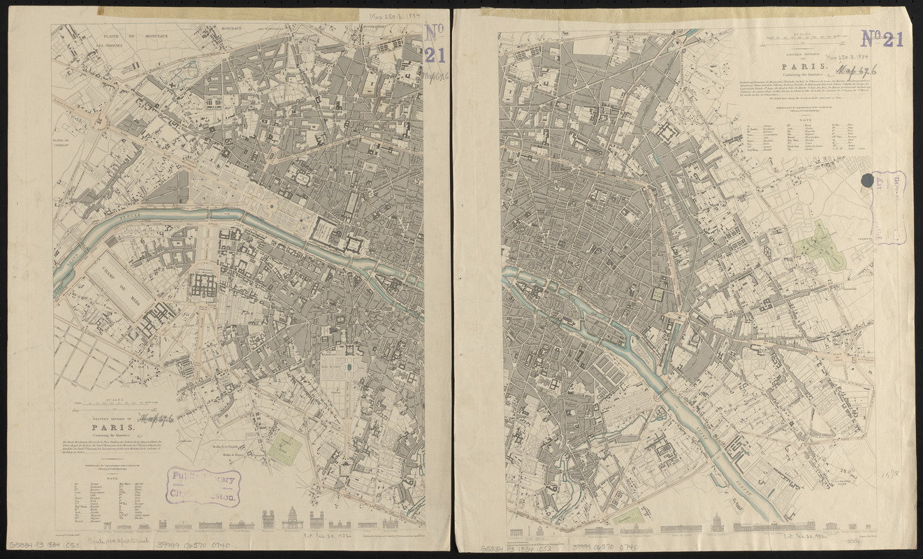
Western division of Paris, containing the quartiers; Eastern division of Paris, containing the quartiers
Western division of Paris, containing the quartiers; Eastern division of Paris, containing the quartiers
×
Item Information
Title:
Western division of Paris, containing the quartiers; Eastern division of Paris, containing the quartiers
Title (alt.):
Eastern division of Paris, containing the quartiers
Cartographer:
Clarke, W. B.
Engraver:
Shury, James
Publisher:
Society for the Diffusion of Useful Knowledge (Great Britain)
Publisher:
Baldwin & Cradock
Name on Item:
drawn by W.B. Clarke ; engraved by J. Shury
Date:
1834
Format:
Maps/Atlases
Location:
Boston Public Library
Norman B. Leventhal Map Center
Collection (local):
Norman B. Leventhal Map Center Collection
Subjects:
Paris (France)--Maps
Places:
France
>
Paris
Extent:
1 map on 2 sheets : color ; 39 x 57 cm, on sheets 42 x 35 cm
Permalink:
https://ark.digitalcommonwealth.org/ark:/50959/0z7095848
Terms of Use:
No known copyright restrictions.
No known restrictions on use.
Publisher:
[London] : Baldwin & Cradock
Scale:
Scale approximately 1:16,000
Language:
English
Table of Contents:
Western division of Paris, containing the quartiers
Eastern Division of Paris, containing the quartiers.
Notes:
Published under the superintendence of the Society for the Diffusion of Useful Knowledge.
Identifier:
06_01_014160
Call #:
G5834.P3 1834 .C53
Barcode:
39999065700740
show more...
View MODS XML
More Like This
Bradshaw's plan of Paris, and map of the environs
Carte routière des environs de Paris, divisés par departemens, ...
Environs de Paris
Exposition universelle de 1867 a Paris : plan du palais à ...
Find More Like This >>
Tools
Share
Facebook
Pinterest
X
Reddit
Tumblr
Email
Copy link
Add to Folder
Questions/Comments
Cite This Item
IIIF Manifest
Downloads
Primary (full resolution, uncompressed)
(TIF, 63.3 MB)
Large (full resolution)
(JPEG, 5.31 MB)
Medium
(JPEG, 449 KB)