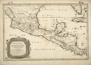
Shows southern United States, Mexico, Central America, northern South America, and West Indies.
Relief shown pictorially.
Prime meridians: London and Ferro.
Appears in Jefferys' General topography of North America and the West Indies. London: Printed for Robert Sayer, ... and Thomas Jefferys, 1768.
Notes (date):
This date is inferred.
Notes (citation):
LC Maps of North America, 1750-1789, 1689
Phillips, P. List of maps of America, p. 1056


![[Mexico and Central America]](https://bpldcassets.blob.core.windows.net/derivatives/images/commonwealth:cj82m4685/image_thumbnail_300.jpg)