Skip to search
Skip to main content
Digital Commonwealth
Sign Up / Log In
Search for
Search
Search
Search
Basic
Advanced
Explore
Map
Collections
Institutions
Formats
For Educators
Primary Source Sets
Lesson Plans
Using Primary Sources
Searching Digital Commonwealth
For Institutions
Join Digital Commonwealth
Conferences, Trainings, & Events
How to Contribute Collections
Digitization Services
Board & Committees
Frequently Asked Questions
About
About Digital Commonwealth
News & Announcements
Copyright & Terms of Use
Harmful Content Statement
Partners
API
Contact Us
Boston Public Library
Norman B. Leventhal Map Center Collection
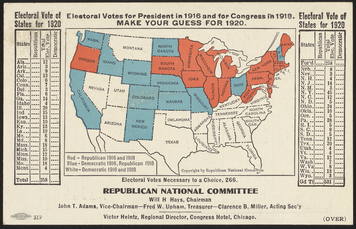
Electoral votes for President in 1916 and for Congress in 1918 : make your guess for 1920
Viewing image 1 of 2
Next >
Electoral votes for President in 1916 and for Congress in 1918
×
Next
Item Information
Title:
Electoral votes for President in 1916 and for Congress in 1918 : make your guess for 1920
Cartographer:
Republican National Committee (U.S.)
Printer:
Allied Printing Trades Council (Chicago, Ill.)
Name on Item:
Republican National Committee
Date:
[1919?]
Format:
Maps/Atlases
Location:
Boston Public Library
Norman B. Leventhal Map Center
Collection (local):
Norman B. Leventhal Map Center Collection
Subjects:
Elections--United States--Maps
United States--Maps
Places:
Extent:
1 map : color ; 6 x 10 cm, on postcard 9 x 14 cm
Permalink:
https://ark.digitalcommonwealth.org/ark:/50959/0r96fq53w
Terms of Use:
No known copyright restrictions.
No known restrictions on use.
Publisher:
[United States] : Republican National Committee
Scale:
Scale approximately 1:45,000,000
Language:
English
Notes:
Map indicates elections results by state for 1916 and 1918. Includes table listing number of electoral votes of states for the 1920 election.
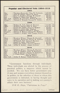
Statistics for Popular and electoral vote 1904-1916 and quote from Will H. Hays on verso.
Identifier:
06_01_016172
06_01_016173
Call #:
G3701.F9 1919 .R47
Barcode:
39999085944666
show more...
View MODS XML
More Like This
Election map of the United States with 49 novel diagrams
Ziron 1920 political map
19th annual convention of the National Association of Real Estate ...
2005 significant U.S. hurricane strikes
Find More Like This >>
Tools
Share
Facebook
Pinterest
X
Reddit
Tumblr
Email
Copy link
Add to Folder
Questions/Comments
Cite This Item
IIIF Manifest
Downloads
Primary (full resolution, uncompressed)
(TIF, multi-file ZIP, 11.4 MB)
Large (full resolution)
(JPEG, multi-file ZIP, 104 KB)
Medium
(JPEG, multi-file ZIP, 629 KB)