Skip to search
Skip to main content
Digital Commonwealth
Sign Up / Log In
Search for
Search
Search
Search
Basic
Advanced
Explore
Map
Collections
Institutions
Formats
For Educators
Primary Source Sets
Lesson Plans
Using Primary Sources
Searching Digital Commonwealth
For Institutions
Join Digital Commonwealth
Conferences, Trainings, & Events
How to Contribute Collections
Digitization Services
Board & Committees
Frequently Asked Questions
About
About Digital Commonwealth
News & Announcements
Copyright & Terms of Use
Harmful Content Statement
Partners
API
Contact Us
Boston Public Library
Norman B. Leventhal Map Center Collection
/
Boston and New England Maps (Collection of Distinction)
/
Maritime Charts and Atlases (Collection of Distinction)
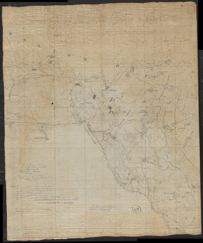
Approaches to Cohasset Harbor Mass. : topography surveyed in 1847 ; hydrography surveyed in 1846-'56
Approaches to Cohasset Harbor Mass.
×
Item Information
Title:
Approaches to Cohasset Harbor Mass. : topography surveyed in 1847 ; hydrography surveyed in 1846-'56
Cartographer:
United States Coast Survey
Name on Item:
traced at the U.S. Coast Survey Office
Date:
1864
Format:
Maps/Atlases
Manuscripts
Location:
Boston Public Library
Norman B. Leventhal Map Center
Collection (local):
Norman B. Leventhal Map Center Collection
Subjects:
Coasts--Massachusetts--Cohasset--Maps
Harbors--Massachusetts--Cohasset--Maps
Cohasset (Mass.)--Maps
Manuscript maps
Places:
Norfolk (county)
>
Cohasset
Extent:
1 manuscript map : hand color ; 108 x 89 cm
Permalink:
https://ark.digitalcommonwealth.org/ark:/50959/0r96fp23z
Terms of Use:
No known copyright restrictions.
No known restrictions on use.
Place of origin:
[Washington, D.C.]
Scale:
Scale 1:10,000
Language:
English
Notes:
Manuscript tracing in ink of an unpublished Coast Survey chart.
Relief shown by contours, hachures and spot heights. Depths shown by soundings and isolines.
Includes notes.
At head of title: U.S. Coast Survey, A.D. Bache Supdt.
Identifier:
06_01_016058
Call #:
G3764.C64P5 1864 .U55
Barcode:
39999085941522
show more...
View MODS XML
More Like This
New topographical atlas of surveys Plymouth County, together with ...
Atlas of the boundaries of the towns of Cohasset - Weymouth, ...
Ashland & Bayfield
Barron County, Wis.
Find More Like This >>
Tools
Share
Facebook
Pinterest
X
Reddit
Tumblr
Email
Copy link
Add to Folder
Questions/Comments
Cite This Item
IIIF Manifest
Downloads
Primary (full resolution, uncompressed)
(TIF, 267 MB)
Large (full resolution)
(JPEG, 22.4 MB)
Medium
(JPEG, 196 KB)