Skip to search
Skip to main content
Digital Commonwealth
Sign Up / Log In
Search for
Search
Search
Search
Basic
Advanced
Explore
Map
Collections
Institutions
Formats
For Educators
Primary Source Sets
Lesson Plans
Using Primary Sources
Searching Digital Commonwealth
For Institutions
Join Digital Commonwealth
Conferences, Trainings, & Events
How to Contribute Collections
Digitization Services
Board & Committees
Frequently Asked Questions
About
About Digital Commonwealth
News & Announcements
Copyright & Terms of Use
Harmful Content Statement
Partners
API
Contact Us
Boston Public Library
Norman B. Leventhal Map Center Collection
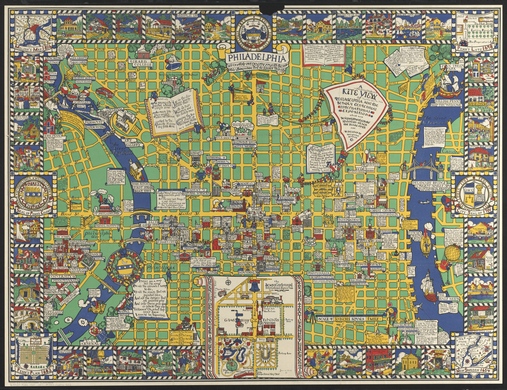
A kite view of Philadelphia and the Sesqui Centennial International Exposition
A kite view of Philadelphia and the Sesqui Centennial International Exposition
×
Item Information
Title:
A kite view of Philadelphia and the Sesqui Centennial International Exposition
Title (alt.):
Kite view of Philadelphia and the Sesquicentennial International Exposition
This is a section of the map of Philadelphia contained in this envelope
Artist:
Olsen, Edwin
Artist:
Clark, Blake, 1900-
Publisher:
Houghton Mifflin Company
Name on Item:
which was designed, drawn, and colored by Edwin Olsen and Blake Clark
Date:
1926
Format:
Maps/Atlases
Location:
Boston Public Library
Norman B. Leventhal Map Center
Collection (local):
Norman B. Leventhal Map Center Collection
Subjects:
Central business districts--Pennsylvania--Philadelphia--Maps
Philadelphia (Pa.)--Maps
Philadelphia (Pa.)--History--Maps
Sesqui-Centennial International Exposition (1926 : Philadelphia, Pa.)
Places:
Philadelphia (county)
>
Philadelphia
Extent:
1 map : color ; 66 x 82 cm, on sheet 74 x 97 cm, folded in envelope 27 x 35 cm
Permalink:
https://ark.digitalcommonwealth.org/ark:/50959/0r96fm962
Terms of Use:
No known copyright restrictions.
No known restrictions on use.
Publisher:
[Boston] : Houghton Mifflin Co.
Scale:
Scale 1:6,336
Language:
English
Notes:
Pictorial map of central area.
Includes historical notes, color illustrations, and coats-of-arms.
Insets: The SesqviCentennial International Exposition -- Penn's plan 1682 -- Melish's map 1816 -- Penn's lots 1698 -- New Sweden 1654.
Identifier:
06_01_014775
Call #:
G3824.P5A5 1926 .O47
Barcode:
39999065705103
show more...
View MODS XML
More Like This
Carte générale des États-Unis de l'Amérique avec les plans des ...
The city of New York as laid out by the Commissioners with the ...
Cyclists' road map of the Philadelphia District
Fac simile of Holmes' map of the Province of Pennsylvania : with ...
Find More Like This >>
Tools
Share
Facebook
Pinterest
X
Reddit
Tumblr
Email
Copy link
Add to Folder
Questions/Comments
Cite This Item
IIIF Manifest
Downloads
Primary (full resolution, uncompressed)
(TIF, 126 MB)
Large (full resolution)
(JPEG, 10.6 MB)
Medium
(JPEG, 710 KB)