Skip to search
Skip to main content
Digital Commonwealth
Sign Up / Log In
Search for
Search
Search
Search
Basic
Advanced
Explore
Map
Collections
Institutions
Formats
For Educators
Primary Source Sets
Lesson Plans
Using Primary Sources
Searching Digital Commonwealth
For Institutions
Join Digital Commonwealth
Conferences, Trainings, & Events
How to Contribute Collections
Digitization Services
Board & Committees
Frequently Asked Questions
About
About Digital Commonwealth
News & Announcements
Copyright & Terms of Use
Harmful Content Statement
Partners
API
Contact Us
Historic New England
Digitized Museum Collections
Map
View this item online at Historic New England
Item Information
Title:
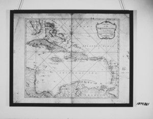
Map
Description:
Rectangular framed map of the "West Indian Islands" with detailed listing of places and islands, etc. showing quadrants and latitude and longitude. Map of Bermuda (1797) on verso; on separate paper.
Publisher:
Laurie & Whittle
Surveyor:
Lempriere, C.
Date:
1795
Format:
Maps/Atlases
Genre:
ink
paper (fiber product)
maps (documents)
Location:
Historic New England
Collection (local):
Digitized Museum Collections
Subjects:
Ink
Unidentified Paper
Places:
Maine
>
York (county)
>
York Harbor
Sayward-Wheeler House (York Harbor, Me.)
Extent:
23 in. x 29.75 in. (H x W); 22.25 in. x 29 in. (H x W)
Link to Item:
http://gusn.us/4001
Terms of Use:
Rights status not evaluated.
Contact host institution for more information.
Notes:
Gift of the heirs of Elizabeth Cheever Wheeler
Accession #:
1977.321
Identifier:
4001
show more...
View MODS XML
More Like This
Advertisement
The Alian Bridge and Castle of St. Angelo
Architectural Drawing
The Area and Church of the Holy Apostles
Find More Like This >>
Tools
Share
Facebook
Pinterest
X
Reddit
Tumblr
Email
Copy link
Add to Folder
Questions/Comments
Cite This Item