Skip to search
Skip to main content
Digital Commonwealth
Sign Up / Log In
Search for
Search
Search
Search
Basic
Advanced
Explore
Map
Collections
Institutions
Formats
For Educators
Primary Source Sets
Lesson Plans
Using Primary Sources
Searching Digital Commonwealth
For Institutions
Join Digital Commonwealth
Conferences, Trainings, & Events
How to Contribute Collections
Digitization Services
Board & Committees
Frequently Asked Questions
About
About Digital Commonwealth
News & Announcements
Copyright & Terms of Use
Harmful Content Statement
Partners
API
Contact Us
Salem State University Archives and Special Collections
Historic Maps
Bristol County
View this item online at Salem State University Archives and Special Collections
Item Information
Title:
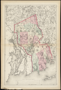
Bristol County
Description:
Shows town boundaries. Relief shown by hachures and spot heights. Title from atlas' table of contents. From: Walling's Official topographical atlas of Massachusetts from astronomical, trigonometrical, and various local surveys. 1871. p. 28-29.
Creator:
Walling, Henry Francis
Date:
1871
Format:
Maps/Atlases
Location:
Salem State University Archives and Special Collections
Collection (local):
Historic Maps
Series:
Massachusetts
Subjects:
Bristol County (Mass.)--Maps
Bristol County
Massachusetts
Places:
Massachusetts
Link to Item:
http://digitalcommons.salemstate.edu/maps_massachusetts/40
Terms of Use:
Rights status not evaluated.
Contact host institution for more information.
Identifier:
G3763B71871
show more...
View MODS XML
More Like This
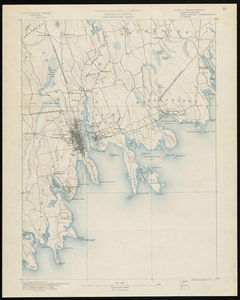
Massachusetts New Bedford Sheet
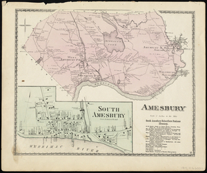
Amesbury
Amesbury
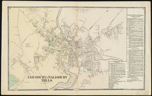
Amesbury & Salisbury Mills
Find More Like This >>
Tools
Share
Facebook
Pinterest
X
Reddit
Tumblr
Email
Copy link
Add to Folder
Questions/Comments
Cite This Item