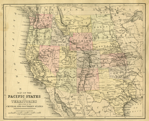
Map of the Pacific States and Territories: With a Part of the Central and Southern States
Description:
Relief shown by hachures. Shows railroads, state and territorial boundaries, cities, towns, military posts, mineral resources, and notable physical features for the western United States; Mississippi River in the eastern portion of the map. Includes notes. Prime meridians: Greenwich and Washington. On verso: [text and questions] Commerce of the United States, 50. Date range based on railroad progress across the United States.