Skip to search
Skip to main content
Digital Commonwealth
Sign Up / Log In
Search for
Search
Search
Search
Basic
Advanced
Explore
Map
Collections
Institutions
Formats
For Educators
Primary Source Sets
Lesson Plans
Using Primary Sources
Searching Digital Commonwealth
For Institutions
Join Digital Commonwealth
Conferences, Trainings, & Events
How to Contribute Collections
Digitization Services
Board & Committees
Frequently Asked Questions
About
About Digital Commonwealth
News & Announcements
Copyright & Terms of Use
Harmful Content Statement
Partners
API
Contact Us
Salem State University Archives and Special Collections
Historic Maps
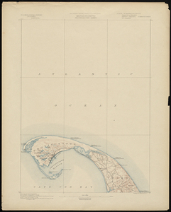
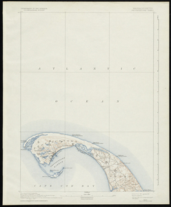
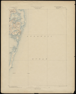
Massachusetts, Provincetown Sheet
View this item online at Salem State University Archives and Special Collections
Item Information
Title:
Massachusetts, Provincetown Sheet
Description:
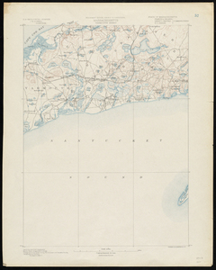
Topographical map of Provincetown. Includes major roads, light houses, life saving stations, and topographical features. Relief is shown by contours. Also shows most of the town of Truro.
Creator:
U.S. Geological Survey
Creator:
Gannett, Henry
Creator:
U.S. Coast and Geodetic and Borden Survey
Creator:
U.S. Coast Survey
Date:
1887
Format:
Maps/Atlases
Location:
Salem State University Archives and Special Collections
Collection (local):
Historic Maps
Series:
Massachusetts
Subjects:
Provincetown (Mass.)--Topographic Maps
Truro (Mass.: Town)--Topographic Maps
Barnstable County
Massachusetts
Places:
Massachusetts
>
Barnstable (county)
>
Provincetown
Link to Item:
http://digitalcommons.salemstate.edu/maps_massachusetts/37
Terms of Use:
Rights status not evaluated.
Contact host institution for more information.
Identifier:
G3764 .P78 1887
show more...
View MODS XML
More Like This
Massachusetts, Provincetown Sheet
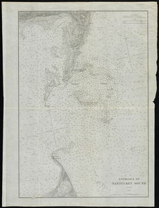
Entrance to Nantucket Sound
Massachusetts, Chatham Sheet
Massachusetts, Yarmouth Sheet
Find More Like This >>
Tools
Share
Facebook
Pinterest
X
Reddit
Tumblr
Email
Copy link
Add to Folder
Questions/Comments
Cite This Item