Boston Water Works: Water-sheds of the Sudbury and Cochituate Supplies
Item Information
- Title:
- Boston Water Works: Water-sheds of the Sudbury and Cochituate Supplies
- Description:
-
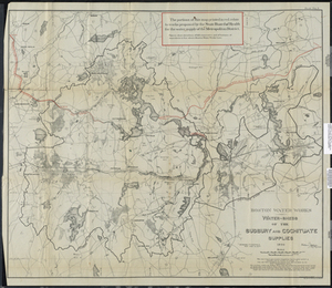
Shows the area from Natick to Westborough and from Hudson to Holliston, Mass. Outlines the Sudbury Divide and the Cochituate Divide. "The portions of this map printed in red relate to works proposed by the State Board of Health for the water supply of the Metropolitan District. Figures show elevations of full reservoirs and of bottoms of aqueducts in feet above Boston Water Works base." Watersheds -- Massachusetts -- Maps, Water Supply -- Massachusetts -- Maps, Sudbury River Watershed (Mass.) -- Maps, Boston, Sudbury, Cochituate, Winthrop Pond, Holliston, Long Hill, Hayden Row, Hopkinton, Ashland, Waushakum Pond, Bear Hill, Sudbury Divide, New York & New England Railroad, Woodville, White Hall Pond, Westborough Water Supply, Fays Mountain, Westborough, Cedar Swamp, Southville, Cordaville, Sudbury River, Fayville, Oak Hill, Wild Cat Hill, Boston & Albany Railroad, Magunco Hill, Farm Pond, Course Brook, Ashland, Sherborn, Sudbury Aqueduct, Framingham, Learned Pond, Cleasons Pond, Dug Pond, State Muster Ground, Toms Hill, Lake Cochituate, Felchville, Saxonville, Nobscot, Dudley Pond, None Such Pond, Snake Brook, Pine Hill, Gibbs Mountain, Nobscot Hill, Williams Pond, Marlborough, Wolfpen Hill, Little Chauncey Pond, Chauncey Pond, Bartlett Pond, Northborough, Assabet River, Solomon Pond, South Berlin, Berlin, Cates Pond, Fitchburg Railroad, Fort Meadow Reservoir, Hudson, Spoon Hill, Heird's Pond, Pickerel Pond, Natick, boston, massachusetts.
- Creator:
- Hopson, Ernest G.
- Creator:
- Boston Water Works
- Date:
-
1894
- Format:
-
Maps/Atlases
- Location:
- Salem State University Archives and Special Collections
- Collection (local):
-
Historic Maps
- Series:
- Boston
- Subjects:
-
Watersheds--Massachusetts--Maps
Water Supply--Massachusetts--Maps
Sudbury River Watershed (Mass.)--Maps
Boston
Sudbury
Cochituate
Winthrop Pond
Holliston
Long Hill
Hayden Row
Hopkinton
Ashland
Waushakum Pond
Bear Hill
Sudbury Divide
New York & New England Railroad
Woodville
White Hall Pond
Westborough Water Supply
Fays Mountain
Westborough
Cedar Swamp
Southville
Cordaville
Sudbury River
Fayville
Oak Hill
Wild Cat Hill
Boston & Albany Railroad
Magunco Hill
Farm Pond
Course Brook
Sherborn
Sudbury Aqueduct
Framingham
Learned Pond
Cleasons Pond
State Muster Ground
Toms Hill
Lake Cochituate
Felchville
Saxonville
Nobscot
Dudley Pond
None Such Pond
Snake Brook
Pine Hill
Gibbs Mountain
Nobscot Hill
Williams Pond
Marlborough
Wolfpen Hill
Little Chauncey Pond
Chauncey Pond
Bartlett Pond
Northborough
Assabet River
Solomon Pond
South Berlin
Berlin
Cates Pond
Fitchburg Railroad
Fort Meadow Reservoir
Hudson
Spoon Hill
Heird's Pond
Pickerel Pond
Dug Pond
Natick
Massachusetts
- Places:
-
Massachusetts
- Link to Item:
- http://digitalcommons.salemstate.edu/maps_boston/62
- Terms of Use:
-
Rights status not evaluated.
Contact host institution for more information.
- Identifier:
-
G 3762 .S93 1894 .H66