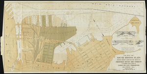
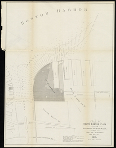
Plan of South Boston Flats Showing Present Condition and Sketch of Proposed Docks and Streets to Accompany Annual Report of Harbor and Land Commissioners
Plan of South Boston Flats Showing Present Condition and Sketch of Proposed Docks and Streets to Accompany Annual Report of Harbor and Land Commissioners
Description:
Soundings are in feet and show depths below mean water. Inset cross section drawings of Commonwealth Pier, Pier 6 South Boston Flats, and sea wall, Nothern Avenue, South Boston. Shows wharves, piers, and location of railroad, businesses, street names, and points of interest. Scale 1: 436. 1 map : col. ; 45 x 90 cm. on sheet 47 x 93 cm.