Skip to search
Skip to main content
Digital Commonwealth
Sign Up / Log In
Search for
Search
Search
Search
Basic
Advanced
Explore
Map
Collections
Institutions
Formats
For Educators
Primary Source Sets
Lesson Plans
Using Primary Sources
Searching Digital Commonwealth
For Institutions
Join Digital Commonwealth
Conferences, Trainings, & Events
How to Contribute Collections
Digitization Services
Board & Committees
Frequently Asked Questions
About
About Digital Commonwealth
News & Announcements
Copyright & Terms of Use
Harmful Content Statement
Partners
API
Contact Us
Salem State University Archives and Special Collections
Historic Maps
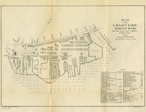
Plan of the U.S. Navy Yard, Boston, Mass. Showing It's Present Condition, June 10, 1883
View this item online at Salem State University Archives and Special Collections
Item Information
Title:
Plan of the U.S. Navy Yard, Boston, Mass. Showing It's Present Condition, June 10, 1883
Description:
Depths shown by soundings. Includes legend and index.
Creator:
United State Bureau of Yards and Docks
Creator:
Mackay,
Date:
1883
Format:
Maps/Atlases
Location:
Salem State University Archives and Special Collections
Collection (local):
Historic Maps
Series:
Coastal or Nautical
Subjects:
Navy-yards and naval stations--Massachusetts--Boston--Maps
Boston (Mass.)--Maps
Charlestown Navy Yard (Boston
Mass.)--Maps
Boston
Massachusetts
Coastal
Places:
Massachusetts
>
Suffolk (county)
>
Boston
Link to Item:
http://digitalcommons.salemstate.edu/maps_boston/9
Terms of Use:
Rights status not evaluated.
Contact host institution for more information.
Identifier:
G 3764 .B6:2 C4 1883 .U5
show more...
View MODS XML
More Like This
Plan of Boston: Comprising a Part of Charlestown and Cambridge
Plan of Boston, Prepared Under the Direction of Otis Clapp ...
Boston Harbor
Boston With its Environs, 1775 & 1776.
Find More Like This >>
Tools
Share
Facebook
Pinterest
X
Reddit
Tumblr
Email
Copy link
Add to Folder
Questions/Comments
Cite This Item