Skip to search
Skip to main content
Digital Commonwealth
Sign Up / Log In
Search for
Search
Search
Search
Basic
Advanced
Explore
Map
Collections
Institutions
Formats
For Educators
Primary Source Sets
Lesson Plans
Using Primary Sources
Searching Digital Commonwealth
For Institutions
Join Digital Commonwealth
Conferences, Trainings, & Events
How to Contribute Collections
Digitization Services
Board & Committees
Frequently Asked Questions
About
About Digital Commonwealth
News & Announcements
Copyright & Terms of Use
Harmful Content Statement
Partners
API
Contact Us
Salem State University Archives and Special Collections
Historic Maps
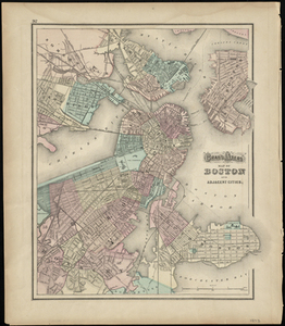
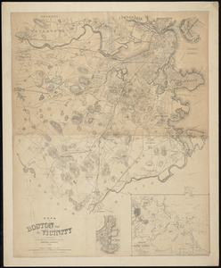
Gray's Atlas Map of Boston and Adjacent Cities
View this item online at Salem State University Archives and Special Collections
Item Information
Title:
Gray's Atlas Map of Boston and Adjacent Cities
Description:
"[p.] 92." On reverse: "Gray's Atlas map of Massachusetts and Rhode Island." Includes Boston, East Boston, South Boston, Cambridge, Roxbury, Charlestown, and part of Dorchester.
Creator:
Ormando Willis Gray
Date:
1873
Format:
Maps/Atlases
Location:
Salem State University Archives and Special Collections
Collection (local):
Historic Maps
Series:
Boston
Subjects:
Boston (Mass.)--Maps
Boston (Mass.)--Administrative and political divisions--Maps
South Boston
Dorchester Bay
Boston Harbor
South Boston Bay
Dorchester
Roxbury
Boston
Charles River
East Boston
Mystic River
Charlestown
Somerville
Cambridge
Chelsea Creek
Chelsea
Mill Pond
Millers River
Massachusetts
Places:
Massachusetts
>
Suffolk (county)
>
Boston
Link to Item:
http://digitalcommons.salemstate.edu/maps_boston/42
Terms of Use:
Rights status not evaluated.
Contact host institution for more information.
Identifier:
G 3764 .B6 1873
show more...
View MODS XML
More Like This
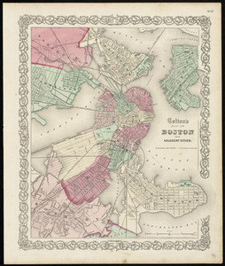
Colton's Map of Boston and Adjacent Cities.
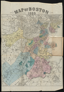
Map of Boston 1886
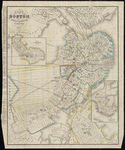
Plan of Boston: Comprising a Part of Charlestown and Cambridge
Plan of Boston and its Vicinity Prepared from the Best Authorities ...
Find More Like This >>
Tools
Share
Facebook
Pinterest
X
Reddit
Tumblr
Email
Copy link
Add to Folder
Questions/Comments
Cite This Item