Rights status not evaluated.
Contact host institution for more information.
Publisher:
Published at the Boston Map Store, E.P. Dutton & Co.
Notes:
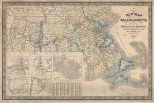
Shows railroads, county and town boundaries, roads, population centers, and natural features; railroads named. Relief shown by hachures. Scale calculated from bar: 1 in. to ca. 6.7 mi. Graticule represented by 70 and 71 [W of Greenwich] and 42- N only; prime meridian not specified. Insets: Salem, Worcester, Boston, Springfield, Lowell. Includes "A Table Showing the distance from Boston to the principal or Shire-Towns of each County; also the distance of each Town in the several Counties from the Shire-Towns of the same; together with the Population of each County & Town, according to the Census of 1840." Population not given.
![[Boston and Northwestern Junction Railroad]](https://bpldcassets.blob.core.windows.net/derivatives/images/commonwealth:x059cc74n/image_thumbnail_300.jpg)


