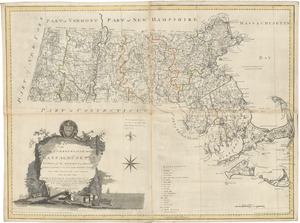
An accurate map of the Commonwealth of Massachusetts exclusive of the District of Maine: compiled pursuant to an act of the General Court from actual surveys of the several towns &c. taken by their order; exhibiting the boundary lines of the Commonwealth, the counties and towns, the principal roads, rivers, mountains, mines, islands, rocks, shoals, channels, lakes, ponds, falls, mills, manufactures & public buildings, with the true latitudes & longitudes, &c.
An accurate map of the Commonwealth of Massachusetts exclusive of the District of Maine: compiled pursuant to an act of the General Court from actual surveys of the several towns &c. taken by their order; exhibiting the boundary lines of the Commonwealth, the counties and towns, the principal roads, rivers, mountains, mines, islands, rocks, shoals, channels, lakes, ponds, falls, mills, manufactures & public buildings, with the true latitudes & longitudes, &c.
Rights status not evaluated.
Contact host institution for more information.
Publisher:
O. Carleton and I. Norman
Notes:
Relief shown pictorially. Prime meridian: Washington. Scale calculated from bar: 1 in. to ca. 4.44 mi.; calculated from graticule: ca. 1:268,950; 40.9 cm./degree of latitude. Shows distance of each town from Boston and the shire town. "Sold also by W. Norman, No. 75 Newbury Street." Wheat and Brunn, No. 214. Produced under contract with the Massachusetts General Court on the basis of maps drawn by each town pursuant to a resolution (originated on Carleton's recommendation) of June 26, 1794; scale to be 4 mi. to the inch (1:253,440); finished work not accepted in this form by the General Court on account of alleged defects in the engraving. Cf. Susan L. Danforth, "The first official maps of Maine and Massachusetts," Imago mundi 35 (1983) p. 37-57.