Virginia
Item Information
- Title:
- Virginia
- Description:
-
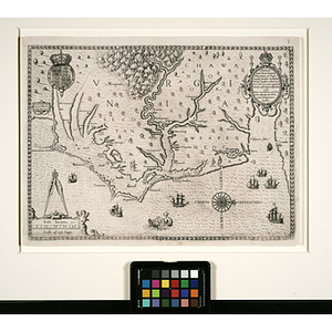
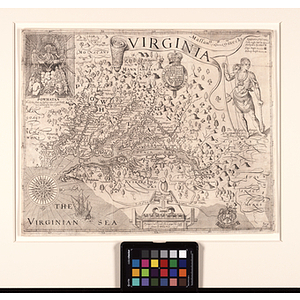
Captain John Smith was one of the greatest early explorers of the Chesapeake area, a founder and early governor of the Jamestown settlement, and an accomplished surveyor. The importance of his map, like his place in history, is impossible to overstate. The most influential map of the area made in the 17th century, Smith's Virginia is remarkable for its detail of the Chesapeake Bay, which Smith himself explored by longboat. The map's detail is so singularly exact that it became the prototype for most later maps of the region until Augustine Herman's great 1673 map Virginia and Maryland. The indication of a large body of water at the upper right of the map signals a large driving force in the formation of the Virginia colony: the persistent belief that a sea route to Asia lay just beyond the mountains. In 1608 Smith spent some months exploring the Chesapeake Bay and the various rivers that fed into it. The extent of his survey is depicted on the map with crosses on the rivers. A key states, "To the crosses hath been discoverd what beyond is by relation." One year later Smith returned to England after sustaining a serious gunpowder wound to his side; he was never to see Virginia again. Nonetheless, his role was vital in ensuring the success of the Jamestown colony, and his map was instrumental in making the geography surrounding the fragile settlement known to Europeans. Many of the names that Smith used on his map persist today, including Capes Henry and Charles, "Poynt Comfort," "Smyths Iles," "Appamatuck" and "Jamesstowne". The map is oriented with north to the right, and contains an animated vignette of the council of Chief Wahunsonacock (known to the English as Powhatan, the father of Pocahontas). It is one of the most important printed maps of America ever produced, and certainly one of the greatest influence, for it was seen widely and inspired much interest in the fledgling Virginia colony. To this day this remarkably detailed map is used by archaeologists to locate native Indian villages. This map is one of the most significant and fascinating early maps of the Chesapeake area.
- Surveyor:
- Smith, John, 1580-1631
- Date:
-
1612
- Format:
-
Documents
Maps/Atlases
- Genre:
-
maps (documents)
historical maps
- Location:
- Northeastern University Library
- Collection (local):
-
Early American and European Maps
- Subjects:
-
Early American Maps
Powhatan Indians
- Places:
-
Virginia
Jamestown (Va.)
Chesapeake Bay (Md. and Va.)
Cape Charles (Va.)
Henry, Cape (Va.)
- Link to Item:
- http://hdl.handle.net/2047/d20129095
- Terms of Use:
-
No Copyright. The organization that has made the Item available believes that the Item is in the Public Domain under the laws of the United States, but a determination was not made as to its copyright status under the copyright laws of other countries. The Item may not be in the Public Domain under the laws of other countries. Please refer to the organization that has made the Item available for more information. http://rightsstatements.org/vocab/NoC-US/1.0/
Contact host institution for more information.
- Place of origin:
-
London
- Notes:
-
The Abstract/Description provided for this map is taken from an accompanying gallery schedule.
- Identifier:
-
american_smith_001