A Map of the Most Inhabited Part of New England... [bottom portion]
![A Map of the Most Inhabited Part of New England... [bottom portion]](https://bpldcassets.blob.core.windows.net/derivatives/metadata/commonwealth-oai:b5645v47s/image_thumbnail_300.jpg)
Item Information
- Title:
- A Map of the Most Inhabited Part of New England... [bottom portion]
- Description:
-
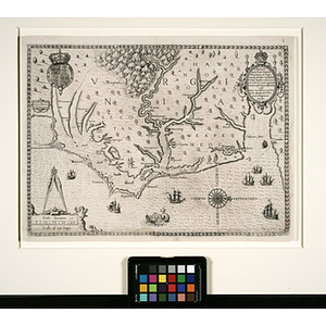
This is the most detailed and informative Revolutionary map of New England, and the first large-scale map of the region. Green's foundational map remained the primary authority for New England cartography until the 19th century, and according to William Cumming, the foremost authority on maps of America, it ranks in importance with Mouzon's "North and South Carolina," Fry and Jefferson's "Virginia and Maryland," and Scull's "Pennsylvania." It includes insets of Boston and Boston Harbor, and the splendid title cartouche, in full original color in this example, depicts the Pilgrims landing at Plymouth. The author, Braddock Mead, alias John Green, was one of the favored cartographers employed by Thomas Jefferys, the foremost publisher of maps in 17th-century Britain. Green carefully collected, analyzed and synthesized information from disparate sources, which he acknowledged on his maps. His groundbreaking map of New England demonstrates an intelligent compilation and careful evaluation of reports on latitudes and longitudes. At a time when the quality and ethics of map production were at a low ebb in England, he vigorously urged and practiced high standards; in the making of maps and nautical charts he was far ahead of his time. Green's New England was one of the foremost maps included in Thomas Jefferys's American Atlas. At a time when England dominated the field of cartography, Thomas Jefferys was at the pinnacle of British map publishing, known for his meticulous attention to accuracy and quality. The most active and celebrated English mapmaker, engraver and publisher, Jefferys gave more attention than any other British cartographer to the colonies in North America. The American Atlas was the most comprehensive cartographic record of the English colonies before and up to the outbreak of the American Revolution: a sweeping and exhaustive overview of all British holdings, which were the subject of major contention. The atlas is an assemblage of plates selected from a number of maps of English America and its parts which had been separately published by Jefferys during the previous two decades. They included the best works of the most noted cartographers of the time, all of them landmark maps by American and European mapmakers. Many of the maps are multi-sheet wall maps, almost without exception the best available for their respective areas for the period. Foremost among them was Green's unprecedented map of New England: a foremost example of the highest quality in 18th-century cartography of America, and one of the most important collaborations of Green and Jefferys.
- Cartographer:
- Green, John, -1757
- Date:
-
1774
- Format:
-
Documents
Maps/Atlases
- Genre:
-
maps (documents)
historical maps
- Location:
- Northeastern University Library
- Collection (local):
-
Early American and European Maps
- Subjects:
-
Early American Maps
- Places:
-
New England
Massachusetts
Connecticut
Rhode Island
Boston (Mass.)
Boston Harbor (Mass.)
Boston Harbor Islands (Mass.)
Plymouth Rock (Plymouth, Mass.)
- Link to Item:
- http://hdl.handle.net/2047/d20129086
- Terms of Use:
-
No Copyright. The organization that has made the Item available believes that the Item is in the Public Domain under the laws of the United States, but a determination was not made as to its copyright status under the copyright laws of other countries. The Item may not be in the Public Domain under the laws of other countries. Please refer to the organization that has made the Item available for more information. http://rightsstatements.org/vocab/NoC-US/1.0/
Contact host institution for more information.
- Publisher:
-
London :
Thomas Jefferys
- Notes:
-
The Abstract/Description provided for this map is taken from an accompanying gallery schedule.
This image displays the bottom portion of "A Map of the Most Inhabited Parts of New England..."
- Identifier:
-
american_green_001a