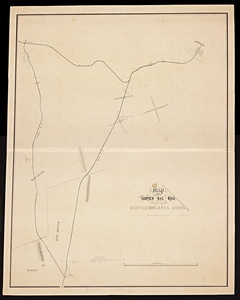
Atlas of the boundaries of the cities of Chicopee and Springfield and towns of Brimfield, East Longmeadow, Hampden, Holland, Longmeadow, Ludlow, Monson, Palmer, Wales, Wilbraham, Hampden County : Belchertown, Granby, South Hadley, Ware, Hampshire County : Brookfield, North Brookfield, Southbridge, Sturbridge, Warren, West Brookfield, Worcester County
Atlas of the boundaries of the cities of Chicopee and Springfield and towns of Brimfield, East Longmeadow, Hampden, Holland, Longmeadow, Ludlow, Monson, Palmer, Wales, Wilbraham, Hampden County : Belchertown, Granby, South Hadley, Ware, Hampshire County : Brookfield, North Brookfield, Southbridge, Sturbridge, Warren, West Brookfield, Worcester County
Title (alt.):
Boundary lines of Belchertown, Brimfield, Brookfield, Chicopee, East Longmeadow, Granby, Hampden, Holland, Longmeadow, Ludlow, Monson, North Brookfield, Palmer, Southbridge, South Hadley, Springfield, Sturbridge, Wales, Ware, Warren, West Brookfield, Wilbraham

![[Map of the Connecticut River from Springfield to Hadley].](https://bpldcassets.blob.core.windows.net/derivatives/metadata/commonwealth-oai:bv73cg33j/image_thumbnail_300.jpg)