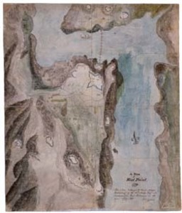
This manuscript map belonged to Captain Moses Greenleaf of the 11th Massachusetts Regiment while he was stationed at West Point. The detailed map shows the locations of fortifications, Fort Putnam, redoubts, buildings, and paths of the area in and around West Point. Also visible is the great chain, a sixty-ton linked chain stretching from Fort Putnam to Constitution Island created by Brigadier General Thaddeus Kosciusko as a barrier for British ships. Manuscript notation on plan: "A Plan of West Point. 1779. This plan belonged to Capt. Moses Greenleaf of the 11th Mass. Regt. who commanded Fort Putnam in the year 1779-80." Signed: "S. Greenleaf."
Item from the collections of the Massachusetts Historical Society. Image use and licensing information: www.masshist.org/library/permissions
Contact host institution for more information.