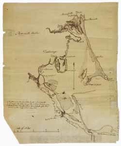
A manuscript map of Plymouth harbor, stretching from Marshfield to the Eel River, including Duxbury. This map is attributed to Jeremy Belknap and includes the wording, "Shows point where the first settlers landed 22 Dec. 1620, the brook where they halted for the first winter, and Clarke's Island."
Item from the collections of the Massachusetts Historical Society. Image use and licensing information: www.masshist.org/library/permissions
Contact host institution for more information.