Skip to search
Skip to main content
Digital Commonwealth
Sign Up / Log In
Search for
Search
Search
Search
Basic
Advanced
Explore
Map
Collections
Institutions
Formats
For Educators
Primary Source Sets
Lesson Plans
Using Primary Sources
Searching Digital Commonwealth
For Institutions
Join Digital Commonwealth
Conferences, Trainings, & Events
How to Contribute Collections
Digitization Services
Board & Committees
Frequently Asked Questions
About
About Digital Commonwealth
News & Announcements
Copyright & Terms of Use
Harmful Content Statement
Partners
API
Contact Us
Historic New England
Nina Heald Webber Cape Cod Canal collection (MS028)
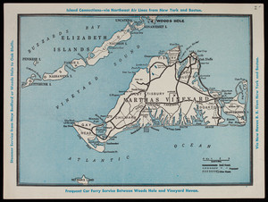
Island Connections via Northeast Air Lines from New York and Boston map
View this item online at Historic New England
Item Information
Title:
Island Connections via Northeast Air Lines from New York and Boston map
Description:
A map illustrating island connections from Martha's Vinyard and the Elizabeth Islands via air, steamer service, amd car ferry.
Date:
2015
Format:
Maps/Atlases
Ephemera
Genre:
transportation maps
Location:
Historic New England
Collection (local):
MS028: Nina Heald Webber Cape Cod Canal collection
Subjects:
airplanes
automobiles
tourism
Tourism
Places:
Massachusetts
>
Cape Cod Canal
Massachusetts
>
Barnstable (county)
>
Cod, Cape
Massachusetts
>
Dukes (county)
>
Elizabeth Islands
(area)
Extent:
1 map
Link to Item:
http://gusn.us/324084
Terms of Use:
Rights status not evaluated.
Contact host institution for more information.
Notes:
Gift of Nina Heald Webber, 2015.
Identifier:
324084
Call #:
MS028.01.010.24
show more...
View MODS XML
More Like This
"1935 Summer Resorts in Southern New England"
Bourne on Cape Cod Massachusetts
"Bournehurst Cape Cod Guide and Theatre Program"
"Buzzards Bay"
Find More Like This >>
Tools
Share
Facebook
Pinterest
X
Reddit
Tumblr
Email
Copy link
Add to Folder
Questions/Comments
Cite This Item