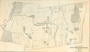
Map of Mass. Agrl. Col. grounds in the vicinity of buildings
Description:
Map of Massachusetts Agricultural College campus shortly before the turn of the 20th century, including the new West and East Experiment Stations, then situated at the northern edge of campus, and the New Chapel (now called Old Chapel), which would become a focal point of campus. From the Student's Handbook, 1893-1894..
All rights for this image are held by the University of Massachusetts Amherst. Requests to publish, redistribute, or replicate this material should be addressed to Special Collections and University Archives, University of Massachusetts Amherst Libraries.
Contact host institution for more information.